You are here: Home > Network List > GS - US Geological Survey Networks Stations List
> Station OK031 S. Brethren Rd., Cushing, OK, USA > Earthquake Result Viewer
OK031 S. Brethren Rd., Cushing, OK, USA - Earthquake Result Viewer
*The percent match for this event was below the threshold and hence no stack was calculated.
| Earthquake location: |
Tonga Islands |
| Earthquake latitude/longitude: |
-20.6/-173.9 |
| Earthquake time(UTC): |
2017/10/18 (291) 12:00:59 GMT |
| Earthquake Depth: |
10 km |
| Earthquake Magnitude: |
6.0 Mww |
| Earthquake Catalog/Contributor: |
NEIC PDE/us |
|
| Network: |
GS US Geological Survey Networks |
| Station: |
OK031 S. Brethren Rd., Cushing, OK, USA |
| Lat/Lon: |
35.95 N/96.84 W |
| Elevation: |
290 m |
|
| Distance: |
92.0 deg |
| Az: |
52.299 deg |
| Baz: |
246.004 deg |
| Ray Param: |
$rayparam |
*The percent match for this event was below the threshold and hence was not used in the summary stack. |
|
| Radial Match: |
33.517647 % |
| Radial Bump: |
400 |
| Transverse Match: |
51.159584 % |
| Transverse Bump: |
400 |
| SOD ConfigId: |
2364251 |
| Insert Time: |
2017-11-01 12:05:18.754 +0000 |
| GWidth: |
2.5 |
| Max Bumps: |
400 |
| Tol: |
0.001 |
|
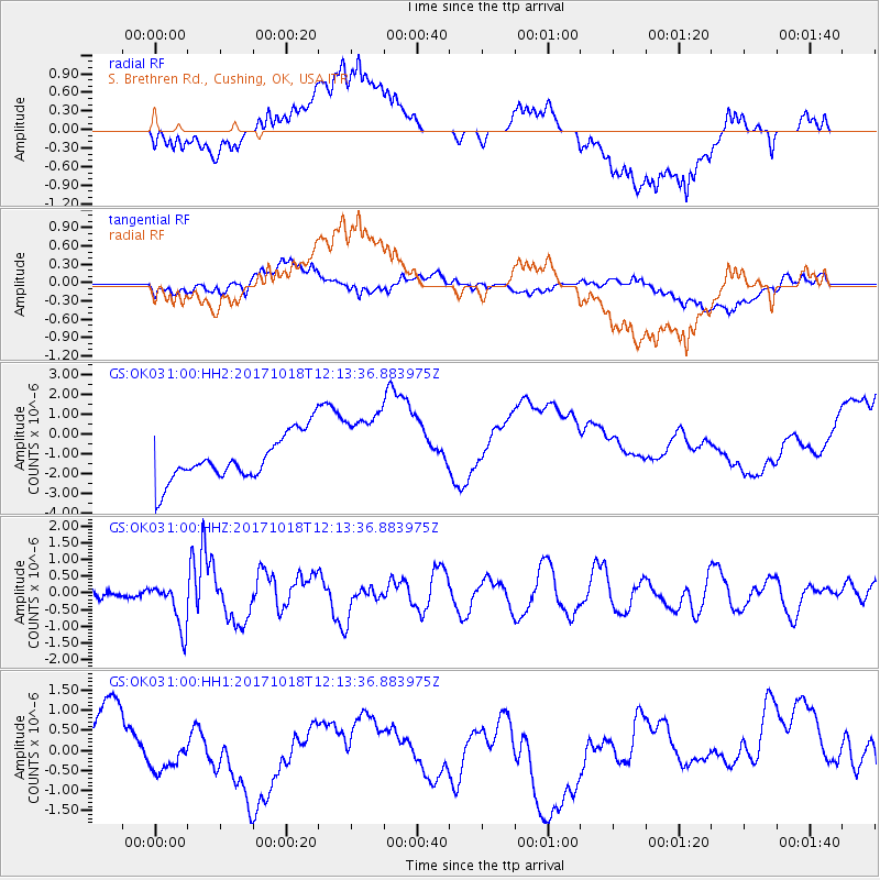
Signal To Noise
| Channel | StoN | STA | LTA |
| GS:OK031:00:HHZ:20171018T12:13:36.883975Z | 6.092141 | 7.107786E-7 | 1.16671394E-7 |
| GS:OK031:00:HH1:20171018T12:13:36.883975Z | 0.4231697 | 3.2256597E-7 | 7.622615E-7 |
| GS:OK031:00:HH2:20171018T12:13:36.883975Z | 1.7534165 | 2.0102939E-6 | 1.1465011E-6 |
| Arrivals |
| Ps | |
| PpPs | |
| PsPs/PpSs | |


