You are here: Home > Network List > IU - Global Seismograph Network (GSN - IRIS/USGS) Stations List
> Station CCM Cathedral Cave, Missouri, USA > Earthquake Result Viewer
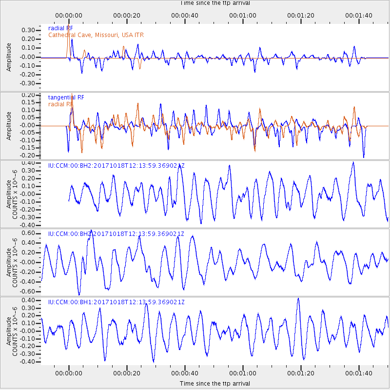
CCM Cathedral Cave, Missouri, USA - Earthquake Result Viewer
*The percent match for this event was below the threshold and hence no stack was calculated.
| Earthquake location: |
Tonga Islands |
| Earthquake latitude/longitude: |
-20.6/-173.9 |
| Earthquake time(UTC): |
2017/10/18 (291) 12:00:59 GMT |
| Earthquake Depth: |
10 km |
| Earthquake Magnitude: |
6.0 Mww |
| Earthquake Catalog/Contributor: |
NEIC PDE/us |
|
| Network: |
IU Global Seismograph Network (GSN - IRIS/USGS) |
| Station: |
CCM Cathedral Cave, Missouri, USA |
| Lat/Lon: |
38.06 N/91.24 W |
| Elevation: |
222 m |
|
| Distance: |
96.9 deg |
| Az: |
52.058 deg |
| Baz: |
249.377 deg |
| Ray Param: |
$rayparam |
*The percent match for this event was below the threshold and hence was not used in the summary stack. |
|
| Radial Match: |
57.186806 % |
| Radial Bump: |
400 |
| Transverse Match: |
46.93382 % |
| Transverse Bump: |
352 |
| SOD ConfigId: |
2364251 |
| Insert Time: |
2017-11-01 12:06:16.667 +0000 |
| GWidth: |
2.5 |
| Max Bumps: |
400 |
| Tol: |
0.001 |
|
Signal To Noise
| Channel | StoN | STA | LTA |
| IU:CCM:00:BHZ:20171018T12:13:59.369021Z | 1.7693754 | 2.8803015E-7 | 1.6278634E-7 |
| IU:CCM:00:BH1:20171018T12:13:59.369021Z | 1.1008948 | 1.4274924E-7 | 1.2966657E-7 |
| IU:CCM:00:BH2:20171018T12:13:59.369021Z | 1.1197929 | 1.2834073E-7 | 1.1461113E-7 |
| Arrivals |
| Ps | |
| PpPs | |
| PsPs/PpSs | |


