You are here: Home > Network List > UW - Pacific Northwest Regional Seismic Network Stations List
> Station HOOD Mt Hood Meadows, OR CREST BB SMO > Earthquake Result Viewer
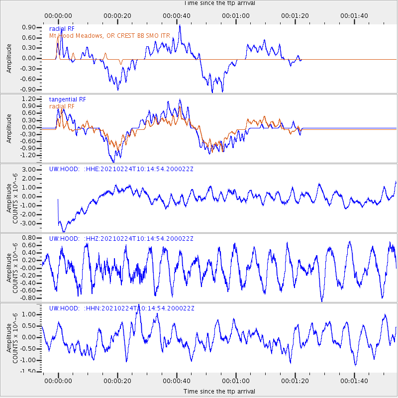
HOOD Mt Hood Meadows, OR CREST BB SMO - Earthquake Result Viewer
*The percent match for this event was below the threshold and hence no stack was calculated.
| Earthquake location: |
Iceland Region |
| Earthquake latitude/longitude: |
63.9/-22.4 |
| Earthquake time(UTC): |
2021/02/24 (055) 10:05:59 GMT |
| Earthquake Depth: |
10 km |
| Earthquake Magnitude: |
5.6 Mww |
| Earthquake Catalog/Contributor: |
NEIC PDE/us |
|
| Network: |
UW Pacific Northwest Regional Seismic Network |
| Station: |
HOOD Mt Hood Meadows, OR CREST BB SMO |
| Lat/Lon: |
45.32 N/121.65 W |
| Elevation: |
1520 m |
|
| Distance: |
54.2 deg |
| Az: |
300.862 deg |
| Baz: |
32.609 deg |
| Ray Param: |
$rayparam |
*The percent match for this event was below the threshold and hence was not used in the summary stack. |
|
| Radial Match: |
43.515354 % |
| Radial Bump: |
400 |
| Transverse Match: |
38.098515 % |
| Transverse Bump: |
400 |
| SOD ConfigId: |
23341671 |
| Insert Time: |
2021-03-10 11:26:47.128 +0000 |
| GWidth: |
2.5 |
| Max Bumps: |
400 |
| Tol: |
0.001 |
|
Signal To Noise
| Channel | StoN | STA | LTA |
| UW:HOOD: :HHZ:20210224T10:14:54.200022Z | 1.4476529 | 3.0739832E-7 | 2.1234256E-7 |
| UW:HOOD: :HHN:20210224T10:14:54.200022Z | 0.81807035 | 6.2680306E-7 | 7.66197E-7 |
| UW:HOOD: :HHE:20210224T10:14:54.200022Z | 0.53322494 | 8.194663E-7 | 1.5368116E-6 |
| Arrivals |
| Ps | |
| PpPs | |
| PsPs/PpSs | |


