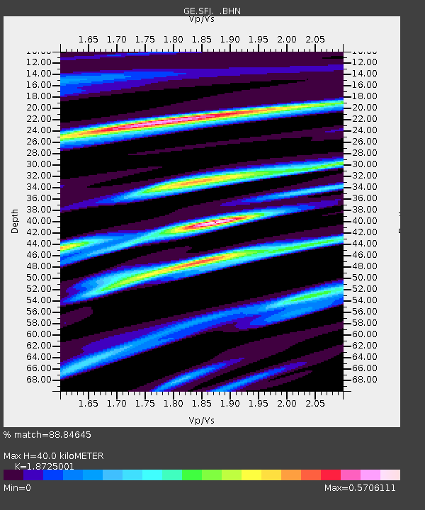
SFJ IRIS/GEOFON Station Sondre Stromfjord, Greenland - Earthquake Result Viewer

Earthquake location: Andreanof Islands, Aleutian Is.
Earthquake latitude/longitude: 51.5/-178.1
Earthquake time(UTC): 1996/06/08 (160) 23:19:15 GMT
Earthquake Depth: 33 km
Earthquake Magnitude: 5.9 MB, 6.3 MS, 6.5 UNKNOWN, 6.1 MS
Earthquake Catalog/Contributor: WHDF/NEIC
Network: GE GEOFON
Station: SFJ IRIS/GEOFON Station Sondre Stromfjord, Greenland
Lat/Lon: 67.00 N/50.62 W
Elevation: 365 m
Distance: 55.4 deg
Az: 22.259 deg
Baz: 322.945 deg
Ray Param: 0.064767525
Estimated Moho Depth: 40.0 km
Estimated Crust Vp/Vs: 1.87
Assumed Crust Vp: 6.459 km/s
Estimated Crust Vs: 3.45 km/s
Estimated Crust Poisson's Ratio: 0.30
Radial Match: 88.84645 %
Radial Bump: 400
Transverse Match: 46.03469 %
Transverse Bump: 400
SOD ConfigId: 6273
Insert Time: 2010-03-09 05:42:48.006 +0000
GWidth: 2.5
Max Bumps: 400
Tol: 0.001

Signal To Noise

ChannelStoNSTALTA
GE:SFJ: :BHN:19960608T23:28:15.328027Z1.85087916.573809E-73.5517226E-7
GE:SFJ: :BHE:19960608T23:28:15.328027Z0.74075672.5447275E-73.4353081E-7
GE:SFJ: :BHZ:19960608T23:28:15.328027Z8.4377751.1709359E-61.3877307E-7
Arrivals
Ps5.7 SECOND
PpPs17 SECOND
PsPs/PpSs23 SECOND