You are here: Home > Network List > GE - GEOFON Stations List
> Station SFJ IRIS/GEOFON Station Sondre Stromfjord, Greenland > Earthquake Result Viewer
SFJ IRIS/GEOFON Station Sondre Stromfjord, Greenland - Earthquake Result Viewer
| Earthquake location: |
Windward Islands |
| Earthquake latitude/longitude: |
11.1/-60.9 |
| Earthquake time(UTC): |
1997/04/22 (112) 09:31:23 GMT |
| Earthquake Depth: |
5.0 km |
| Earthquake Magnitude: |
6.0 MB, 6.5 MS, 6.7 UNKNOWN, 6.1 ME |
| Earthquake Catalog/Contributor: |
WHDF/NEIC |
|
| Network: |
GE GEOFON |
| Station: |
SFJ IRIS/GEOFON Station Sondre Stromfjord, Greenland |
| Lat/Lon: |
67.00 N/50.62 W |
| Elevation: |
365 m |
|
| Distance: |
56.2 deg |
| Az: |
4.837 deg |
| Baz: |
192.157 deg |
| Ray Param: |
0.064278826 |
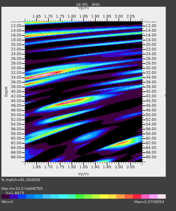
| Estimated Moho Depth: |
33.0 km |
| Estimated Crust Vp/Vs: |
1.67 |
| Assumed Crust Vp: |
6.459 km/s |
| Estimated Crust Vs: |
3.874 km/s |
| Estimated Crust Poisson's Ratio: |
0.22 |
|
| Radial Match: |
91.084885 % |
| Radial Bump: |
400 |
| Transverse Match: |
73.80057 % |
| Transverse Bump: |
400 |
| SOD ConfigId: |
6273 |
| Insert Time: |
2010-03-09 05:42:51.438 +0000 |
| GWidth: |
2.5 |
| Max Bumps: |
400 |
| Tol: |
0.001 |
|

Signal To Noise
| Channel | StoN | STA | LTA |
| GE:SFJ: :BHN:19970422T09:40:33.34502Z | 1.8311312 | 3.1902937E-7 | 1.7422529E-7 |
| GE:SFJ: :BHE:19970422T09:40:33.34502Z | 0.92592835 | 2.5815865E-7 | 2.788106E-7 |
| GE:SFJ: :BHZ:19970422T09:40:33.34502Z | 2.02197 | 5.765962E-7 | 2.8516556E-7 |
| Arrivals |
| Ps | 3.6 SECOND |
| PpPs | 13 SECOND |
| PsPs/PpSs | 17 SECOND |


