You are here: Home > Network List > GE - GEOFON Stations List
> Station SFJ IRIS/GEOFON Station Sondre Stromfjord, Greenland > Earthquake Result Viewer
SFJ IRIS/GEOFON Station Sondre Stromfjord, Greenland - Earthquake Result Viewer
| Earthquake location: |
Northern Peru |
| Earthquake latitude/longitude: |
-4.4/-76.7 |
| Earthquake time(UTC): |
1997/10/28 (301) 06:15:17 GMT |
| Earthquake Depth: |
112 km |
| Earthquake Magnitude: |
6.6 MB, 6.3 MS, 7.2 UNKNOWN, 6.6 ME |
| Earthquake Catalog/Contributor: |
WHDF/NEIC |
|
| Network: |
GE GEOFON |
| Station: |
SFJ IRIS/GEOFON Station Sondre Stromfjord, Greenland |
| Lat/Lon: |
67.00 N/50.62 W |
| Elevation: |
365 m |
|
| Distance: |
73.6 deg |
| Az: |
10.371 deg |
| Baz: |
207.177 deg |
| Ray Param: |
0.05262565 |
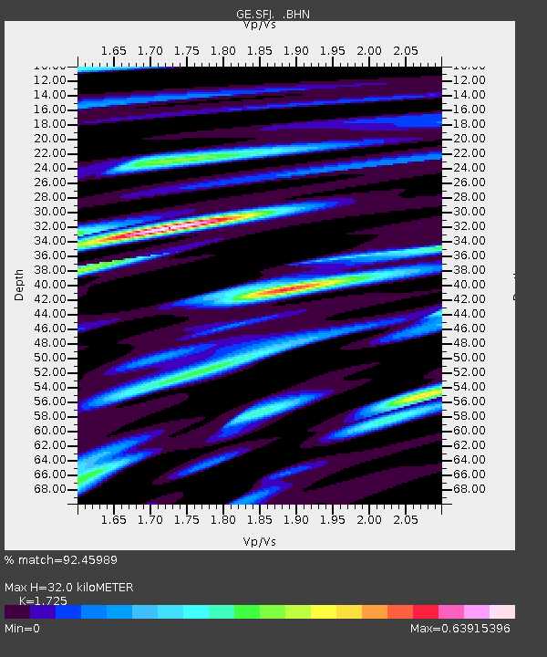
| Estimated Moho Depth: |
32.0 km |
| Estimated Crust Vp/Vs: |
1.73 |
| Assumed Crust Vp: |
6.459 km/s |
| Estimated Crust Vs: |
3.745 km/s |
| Estimated Crust Poisson's Ratio: |
0.25 |
|
| Radial Match: |
92.45989 % |
| Radial Bump: |
400 |
| Transverse Match: |
84.65751 % |
| Transverse Bump: |
400 |
| SOD ConfigId: |
6273 |
| Insert Time: |
2010-03-09 05:42:52.624 +0000 |
| GWidth: |
2.5 |
| Max Bumps: |
400 |
| Tol: |
0.001 |
|

Signal To Noise
| Channel | StoN | STA | LTA |
| GE:SFJ: :BHN:19971028T06:26:07.378003Z | 5.5544567 | 1.2804836E-6 | 2.3053265E-7 |
| GE:SFJ: :BHE:19971028T06:26:07.378003Z | 1.9143618 | 8.179599E-7 | 4.272755E-7 |
| GE:SFJ: :BHZ:19971028T06:26:07.378003Z | 8.709688 | 3.8924295E-6 | 4.4690805E-7 |
| Arrivals |
| Ps | 3.7 SECOND |
| PpPs | 13 SECOND |
| PsPs/PpSs | 17 SECOND |


