You are here: Home > Network List > GE - GEOFON Stations List
> Station SFJ IRIS/GEOFON Station Sondre Stromfjord, Greenland > Earthquake Result Viewer
SFJ IRIS/GEOFON Station Sondre Stromfjord, Greenland - Earthquake Result Viewer
| Earthquake location: |
Azores Islands, Portugal |
| Earthquake latitude/longitude: |
38.7/-28.6 |
| Earthquake time(UTC): |
1998/07/09 (190) 05:19:07 GMT |
| Earthquake Depth: |
10 km |
| Earthquake Magnitude: |
5.7 MB, 6.0 MS, 6.6 UNKNOWN, 6.2 MW |
| Earthquake Catalog/Contributor: |
WHDF/NEIC |
|
| Network: |
GE GEOFON |
| Station: |
SFJ IRIS/GEOFON Station Sondre Stromfjord, Greenland |
| Lat/Lon: |
67.00 N/50.62 W |
| Elevation: |
365 m |
|
| Distance: |
31.0 deg |
| Az: |
343.391 deg |
| Baz: |
145.284 deg |
| Ray Param: |
0.079188265 |
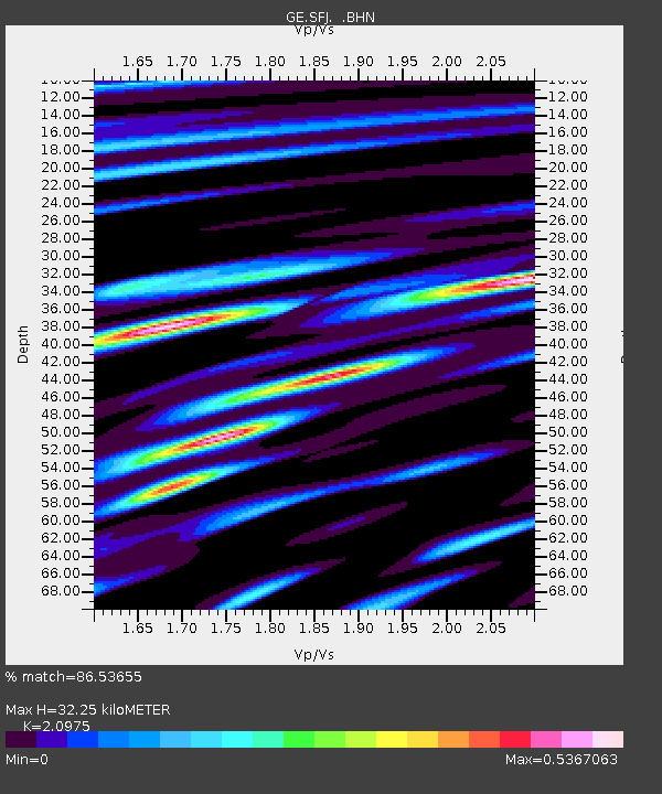
| Estimated Moho Depth: |
32.25 km |
| Estimated Crust Vp/Vs: |
2.10 |
| Assumed Crust Vp: |
6.459 km/s |
| Estimated Crust Vs: |
3.08 km/s |
| Estimated Crust Poisson's Ratio: |
0.35 |
|
| Radial Match: |
86.53655 % |
| Radial Bump: |
400 |
| Transverse Match: |
53.245186 % |
| Transverse Bump: |
400 |
| SOD ConfigId: |
4480 |
| Insert Time: |
2010-03-09 05:42:58.930 +0000 |
| GWidth: |
2.5 |
| Max Bumps: |
400 |
| Tol: |
0.001 |
|

Signal To Noise
| Channel | StoN | STA | LTA |
| GE:SFJ: :BHN:19980709T05:24:54.026013Z | 7.136404 | 8.692262E-7 | 1.218017E-7 |
| GE:SFJ: :BHE:19980709T05:24:54.026013Z | 4.737472 | 4.2292123E-7 | 8.92715E-8 |
| GE:SFJ: :BHZ:19980709T05:24:54.026013Z | 3.8320127 | 3.5356763E-7 | 9.226682E-8 |
| Arrivals |
| Ps | 5.9 SECOND |
| PpPs | 14 SECOND |
| PsPs/PpSs | 20 SECOND |


