You are here: Home > Network List > GE - GEOFON Stations List
> Station SFJ IRIS/GEOFON Station Sondre Stromfjord, Greenland > Earthquake Result Viewer
SFJ IRIS/GEOFON Station Sondre Stromfjord, Greenland - Earthquake Result Viewer
| Earthquake location: |
Sakhalin, Russia |
| Earthquake latitude/longitude: |
48.8/142.2 |
| Earthquake time(UTC): |
2000/08/04 (217) 21:13:02 GMT |
| Earthquake Depth: |
10 km |
| Earthquake Magnitude: |
6.3 MB, 7.1 MS, 6.8 MW, 6.7 MW |
| Earthquake Catalog/Contributor: |
WHDF/NEIC |
|
| Network: |
GE GEOFON |
| Station: |
SFJ IRIS/GEOFON Station Sondre Stromfjord, Greenland |
| Lat/Lon: |
67.00 N/50.62 W |
| Elevation: |
365 m |
|
| Distance: |
64.1 deg |
| Az: |
5.579 deg |
| Baz: |
350.583 deg |
| Ray Param: |
0.059120506 |
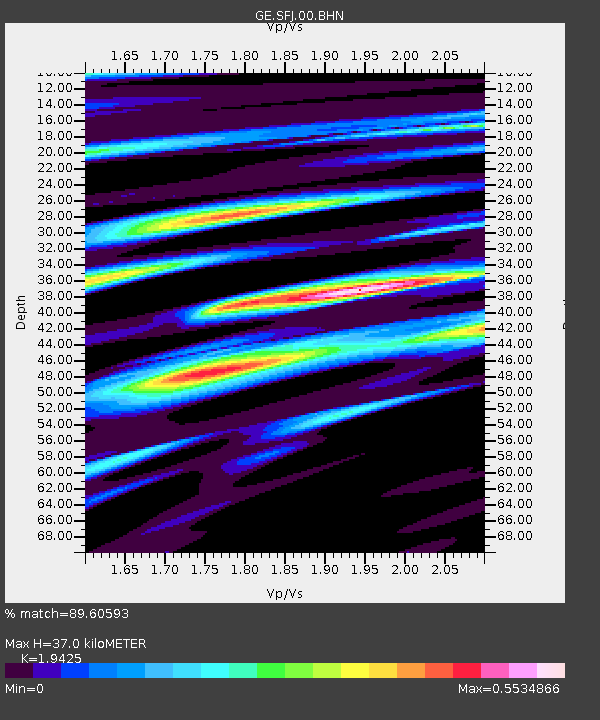
| Estimated Moho Depth: |
37.0 km |
| Estimated Crust Vp/Vs: |
1.94 |
| Assumed Crust Vp: |
6.459 km/s |
| Estimated Crust Vs: |
3.325 km/s |
| Estimated Crust Poisson's Ratio: |
0.32 |
|
| Radial Match: |
89.60593 % |
| Radial Bump: |
400 |
| Transverse Match: |
64.63859 % |
| Transverse Bump: |
400 |
| SOD ConfigId: |
20082 |
| Insert Time: |
2010-03-09 05:43:06.908 +0000 |
| GWidth: |
2.5 |
| Max Bumps: |
400 |
| Tol: |
0.001 |
|

Signal To Noise
| Channel | StoN | STA | LTA |
| GE:SFJ:00:BHN:20000804T21:23:05.960Z | 7.858145 | 1.0215025E-6 | 1.2999281E-7 |
| GE:SFJ:00:BHE:20000804T21:23:05.960Z | 1.1320738 | 1.7434569E-7 | 1.5400559E-7 |
| GE:SFJ:00:BHZ:20000804T21:23:05.960Z | 15.701673 | 2.0004688E-6 | 1.2740483E-7 |
| Arrivals |
| Ps | 5.6 SECOND |
| PpPs | 16 SECOND |
| PsPs/PpSs | 22 SECOND |


