You are here: Home > Network List > GE - GEOFON Stations List
> Station SFJ IRIS/GEOFON Station Sondre Stromfjord, Greenland > Earthquake Result Viewer
SFJ IRIS/GEOFON Station Sondre Stromfjord, Greenland - Earthquake Result Viewer
| Earthquake location: |
Central Mexico |
| Earthquake latitude/longitude: |
18.4/-98.9 |
| Earthquake time(UTC): |
2000/07/21 (203) 06:13:41 GMT |
| Earthquake Depth: |
80 km |
| Earthquake Magnitude: |
5.4 MB, 5.1 MS, 5.9 MW, 4.8 MD |
| Earthquake Catalog/Contributor: |
WHDF/NEIC |
|
| Network: |
GE GEOFON |
| Station: |
SFJ IRIS/GEOFON Station Sondre Stromfjord, Greenland |
| Lat/Lon: |
67.00 N/50.62 W |
| Elevation: |
365 m |
|
| Distance: |
57.5 deg |
| Az: |
20.355 deg |
| Baz: |
237.17 deg |
| Ray Param: |
0.06321691 |
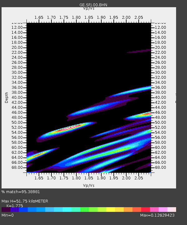
| Estimated Moho Depth: |
51.75 km |
| Estimated Crust Vp/Vs: |
1.77 |
| Assumed Crust Vp: |
6.459 km/s |
| Estimated Crust Vs: |
3.639 km/s |
| Estimated Crust Poisson's Ratio: |
0.27 |
|
| Radial Match: |
95.38981 % |
| Radial Bump: |
400 |
| Transverse Match: |
74.30576 % |
| Transverse Bump: |
400 |
| SOD ConfigId: |
20082 |
| Insert Time: |
2010-03-09 05:43:08.116 +0000 |
| GWidth: |
2.5 |
| Max Bumps: |
400 |
| Tol: |
0.001 |
|

Signal To Noise
| Channel | StoN | STA | LTA |
| GE:SFJ:00:BHN:20000721T06:22:51.759016Z | 1.0918688 | 1.5650033E-7 | 1.4333254E-7 |
| GE:SFJ:00:BHE:20000721T06:22:51.759016Z | 0.937045 | 1.9334881E-7 | 2.0633888E-7 |
| GE:SFJ:00:BHZ:20000721T06:22:51.759016Z | 1.9980896 | 7.5921776E-7 | 3.7997182E-7 |
| Arrivals |
| Ps | 6.5 SECOND |
| PpPs | 21 SECOND |
| PsPs/PpSs | 28 SECOND |


