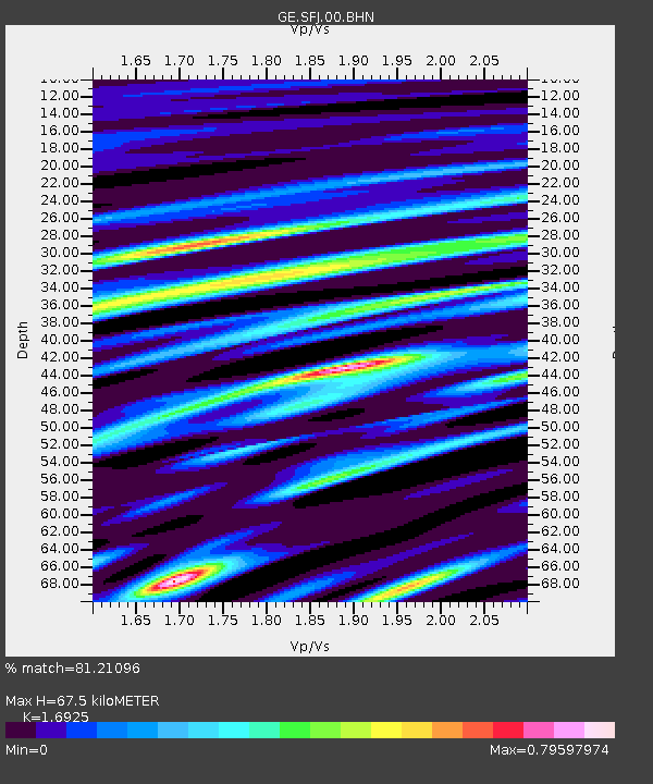
SFJ IRIS/GEOFON Station Sondre Stromfjord, Greenland - Earthquake Result Viewer

Earthquake location: Near East Coast Of Honshu, Japan
Earthquake latitude/longitude: 36.5/141.0
Earthquake time(UTC): 2000/07/20 (202) 18:39:18 GMT
Earthquake Depth: 47 km
Earthquake Magnitude: 6.1 MB, 5.4 MS, 6.1 ME, 6.0 MW
Earthquake Catalog/Contributor: WHDF/NEIC
Network: GE GEOFON
Station: SFJ IRIS/GEOFON Station Sondre Stromfjord, Greenland
Lat/Lon: 67.00 N/50.62 W
Elevation: 365 m
Distance: 76.4 deg
Az: 4.662 deg
Baz: 350.408 deg
Ray Param: 0.05091207
Estimated Moho Depth: 67.5 km
Estimated Crust Vp/Vs: 1.69
Assumed Crust Vp: 6.459 km/s
Estimated Crust Vs: 3.817 km/s
Estimated Crust Poisson's Ratio: 0.23
Radial Match: 81.21096 %
Radial Bump: 400
Transverse Match: 54.359234 %
Transverse Bump: 400
SOD ConfigId: 20082
Insert Time: 2010-03-09 05:43:10.494 +0000
GWidth: 2.5
Max Bumps: 400
Tol: 0.001

Signal To Noise

ChannelStoNSTALTA
GE:SFJ:00:BHN:20000720T18:50:32.510002Z4.94198377.3302283E-71.4832563E-7
GE:SFJ:00:BHE:20000720T18:50:32.510002Z1.97765455.0419106E-72.5494396E-7
GE:SFJ:00:BHZ:20000720T18:50:32.510002Z36.4238621.893247E-65.1978205E-8
Arrivals
Ps7.5 SECOND
PpPs27 SECOND
PsPs/PpSs35 SECOND