You are here: Home > Network List > US - United States National Seismic Network Stations List
> Station TPNV Topopah Spring, Nevada, USA > Earthquake Result Viewer
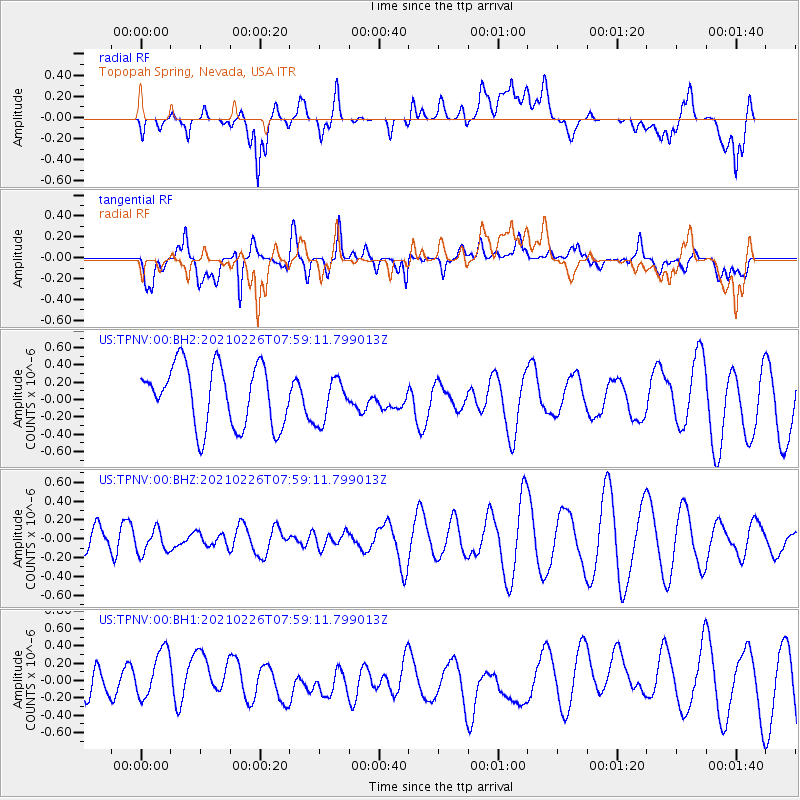
TPNV Topopah Spring, Nevada, USA - Earthquake Result Viewer
*The percent match for this event was below the threshold and hence no stack was calculated.
| Earthquake location: |
W. Caroline Islands, Micronesia |
| Earthquake latitude/longitude: |
8.5/137.8 |
| Earthquake time(UTC): |
2021/02/26 (057) 07:46:09 GMT |
| Earthquake Depth: |
10 km |
| Earthquake Magnitude: |
5.5 Mww |
| Earthquake Catalog/Contributor: |
NEIC PDE/us |
|
| Network: |
US United States National Seismic Network |
| Station: |
TPNV Topopah Spring, Nevada, USA |
| Lat/Lon: |
36.95 N/116.25 W |
| Elevation: |
1600 m |
|
| Distance: |
97.5 deg |
| Az: |
50.961 deg |
| Baz: |
286.457 deg |
| Ray Param: |
$rayparam |
*The percent match for this event was below the threshold and hence was not used in the summary stack. |
|
| Radial Match: |
47.943726 % |
| Radial Bump: |
400 |
| Transverse Match: |
72.71752 % |
| Transverse Bump: |
400 |
| SOD ConfigId: |
23341671 |
| Insert Time: |
2021-03-12 08:57:24.468 +0000 |
| GWidth: |
2.5 |
| Max Bumps: |
400 |
| Tol: |
0.001 |
|
Signal To Noise
| Channel | StoN | STA | LTA |
| US:TPNV:00:BHZ:20210226T07:59:11.799013Z | 1.0770202 | 1.2982711E-7 | 1.2054288E-7 |
| US:TPNV:00:BH1:20210226T07:59:11.799013Z | 1.9133697 | 3.1307468E-7 | 1.6362478E-7 |
| US:TPNV:00:BH2:20210226T07:59:11.799013Z | 0.715858 | 2.4991073E-7 | 3.4910659E-7 |
| Arrivals |
| Ps | |
| PpPs | |
| PsPs/PpSs | |


