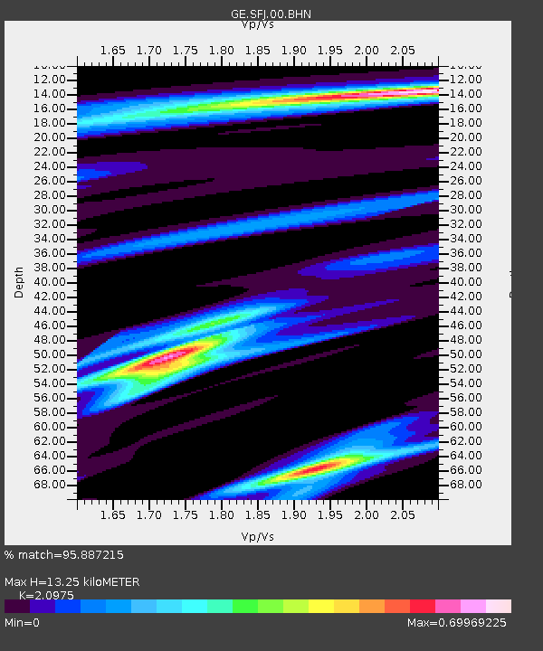
SFJ IRIS/GEOFON Station Sondre Stromfjord, Greenland - Earthquake Result Viewer

Earthquake location: Near Coast Of Jalisco, Mexico
Earthquake latitude/longitude: 18.8/-104.1
Earthquake time(UTC): 2003/01/22 (022) 02:06:34 GMT
Earthquake Depth: 24 km
Earthquake Magnitude: 6.5 MB, 7.6 MS, 7.6 MW, 7.4 MW
Earthquake Catalog/Contributor: WHDF/NEIC
Network: GE GEOFON
Station: SFJ IRIS/GEOFON Station Sondre Stromfjord, Greenland
Lat/Lon: 67.00 N/50.62 W
Elevation: 365 m
Distance: 59.0 deg
Az: 21.634 deg
Baz: 242.722 deg
Ray Param: 0.062471535
Estimated Moho Depth: 13.25 km
Estimated Crust Vp/Vs: 2.10
Assumed Crust Vp: 6.459 km/s
Estimated Crust Vs: 3.08 km/s
Estimated Crust Poisson's Ratio: 0.35
Radial Match: 95.887215 %
Radial Bump: 358
Transverse Match: 81.8969 %
Transverse Bump: 400
SOD ConfigId: 4714
Insert Time: 2010-03-09 05:43:35.476 +0000
GWidth: 2.5
Max Bumps: 400
Tol: 0.001

Signal To Noise

ChannelStoNSTALTA
GE:SFJ:00:BHN:20030122T02:16:01.023025Z1.50438981.5592349E-61.0364568E-6
GE:SFJ:00:BHE:20030122T02:16:01.023025Z2.78926562.0496568E-67.3483744E-7
GE:SFJ:00:BHZ:20030122T02:16:01.023025Z3.27280715.0018357E-61.5283015E-6
Arrivals
Ps2.3 SECOND
PpPs6.1 SECOND
PsPs/PpSs8.4 SECOND