You are here: Home > Network List > TA - USArray Transportable Network (new EarthScope stations) Stations List
> Station TUL3 Leonard, OK, USA > Earthquake Result Viewer
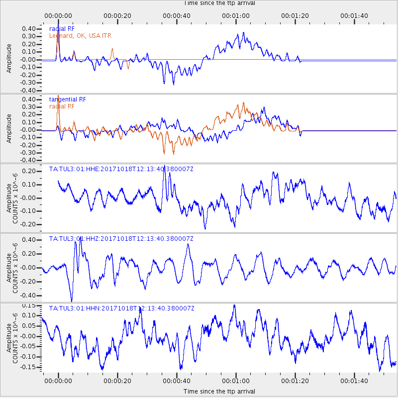
TUL3 Leonard, OK, USA - Earthquake Result Viewer
*The percent match for this event was below the threshold and hence no stack was calculated.
| Earthquake location: |
Tonga Islands |
| Earthquake latitude/longitude: |
-20.6/-173.9 |
| Earthquake time(UTC): |
2017/10/18 (291) 12:00:59 GMT |
| Earthquake Depth: |
10 km |
| Earthquake Magnitude: |
6.0 Mww |
| Earthquake Catalog/Contributor: |
NEIC PDE/us |
|
| Network: |
TA USArray Transportable Network (new EarthScope stations) |
| Station: |
TUL3 Leonard, OK, USA |
| Lat/Lon: |
35.91 N/95.79 W |
| Elevation: |
265 m |
|
| Distance: |
92.7 deg |
| Az: |
52.68 deg |
| Baz: |
246.6 deg |
| Ray Param: |
$rayparam |
*The percent match for this event was below the threshold and hence was not used in the summary stack. |
|
| Radial Match: |
61.460464 % |
| Radial Bump: |
400 |
| Transverse Match: |
46.52489 % |
| Transverse Bump: |
400 |
| SOD ConfigId: |
2364251 |
| Insert Time: |
2017-11-01 12:09:04.098 +0000 |
| GWidth: |
2.5 |
| Max Bumps: |
400 |
| Tol: |
0.001 |
|
Signal To Noise
| Channel | StoN | STA | LTA |
| TA:TUL3:01:HHZ:20171018T12:13:40.380007Z | 7.0743904 | 1.8303055E-7 | 2.5872273E-8 |
| TA:TUL3:01:HHN:20171018T12:13:40.380007Z | 1.4258765 | 6.114762E-8 | 4.2884228E-8 |
| TA:TUL3:01:HHE:20171018T12:13:40.380007Z | 1.2762134 | 6.0883906E-8 | 4.770668E-8 |
| Arrivals |
| Ps | |
| PpPs | |
| PsPs/PpSs | |


