You are here: Home > Network List > TX - Texas Seismological Network Stations List
> Station FW06 Azle > Earthquake Result Viewer
FW06 Azle - Earthquake Result Viewer
| Earthquake location: |
Tonga Islands |
| Earthquake latitude/longitude: |
-20.6/-173.9 |
| Earthquake time(UTC): |
2017/10/18 (291) 12:00:59 GMT |
| Earthquake Depth: |
10 km |
| Earthquake Magnitude: |
6.0 Mww |
| Earthquake Catalog/Contributor: |
NEIC PDE/us |
|
| Network: |
TX Texas Seismological Network |
| Station: |
FW06 Azle |
| Lat/Lon: |
32.97 N/97.56 W |
| Elevation: |
233 m |
|
| Distance: |
90.2 deg |
| Az: |
54.767 deg |
| Baz: |
245.553 deg |
| Ray Param: |
0.041690554 |
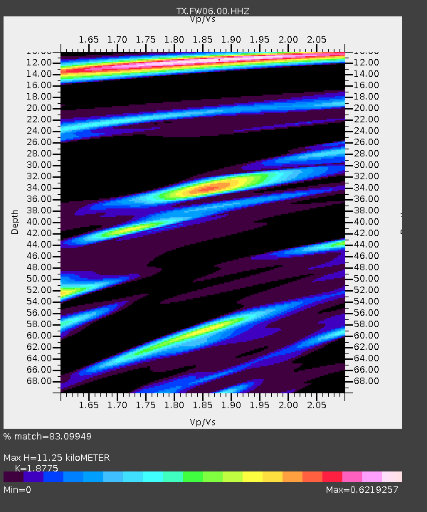
| Estimated Moho Depth: |
11.25 km |
| Estimated Crust Vp/Vs: |
1.88 |
| Assumed Crust Vp: |
6.38 km/s |
| Estimated Crust Vs: |
3.398 km/s |
| Estimated Crust Poisson's Ratio: |
0.30 |
|
| Radial Match: |
83.09949 % |
| Radial Bump: |
286 |
| Transverse Match: |
71.510284 % |
| Transverse Bump: |
349 |
| SOD ConfigId: |
2364251 |
| Insert Time: |
2017-11-01 12:09:14.071 +0000 |
| GWidth: |
2.5 |
| Max Bumps: |
400 |
| Tol: |
0.001 |
|

Signal To Noise
| Channel | StoN | STA | LTA |
| TX:FW06:00:HHZ:20171018T12:13:28.739993Z | 3.3579738 | 5.949668E-7 | 1.771803E-7 |
| TX:FW06:00:HH1:20171018T12:13:28.739993Z | 1.1490062 | 8.629425E-8 | 7.510337E-8 |
| TX:FW06:00:HH2:20171018T12:13:28.739993Z | 2.8428824 | 4.3853885E-7 | 1.5425853E-7 |
| Arrivals |
| Ps | 1.6 SECOND |
| PpPs | 5.0 SECOND |
| PsPs/PpSs | 6.6 SECOND |


