You are here: Home > Network List > TX - Texas Seismological Network Stations List
> Station SN01 Snyder 1 > Earthquake Result Viewer
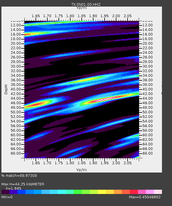
SN01 Snyder 1 - Earthquake Result Viewer
| Earthquake location: |
Tonga Islands |
| Earthquake latitude/longitude: |
-20.6/-173.9 |
| Earthquake time(UTC): |
2017/10/18 (291) 12:00:59 GMT |
| Earthquake Depth: |
10 km |
| Earthquake Magnitude: |
6.0 Mww |
| Earthquake Catalog/Contributor: |
NEIC PDE/us |
|
| Network: |
TX Texas Seismological Network |
| Station: |
SN01 Snyder 1 |
| Lat/Lon: |
32.86 N/100.89 W |
| Elevation: |
717 m |
|
| Distance: |
87.6 deg |
| Az: |
53.667 deg |
| Baz: |
243.729 deg |
| Ray Param: |
0.043197326 |
| Estimated Moho Depth: |
44.25 km |
| Estimated Crust Vp/Vs: |
1.95 |
| Assumed Crust Vp: |
6.426 km/s |
| Estimated Crust Vs: |
3.304 km/s |
| Estimated Crust Poisson's Ratio: |
0.32 |
|
| Radial Match: |
88.97308 % |
| Radial Bump: |
318 |
| Transverse Match: |
68.86418 % |
| Transverse Bump: |
323 |
| SOD ConfigId: |
2364251 |
| Insert Time: |
2017-11-01 12:10:09.825 +0000 |
| GWidth: |
2.5 |
| Max Bumps: |
400 |
| Tol: |
0.001 |
|

Signal To Noise
| Channel | StoN | STA | LTA |
| TX:SN01:00:HHZ:20171018T12:13:16.609988Z | 5.2416654 | 9.673175E-7 | 1.8454394E-7 |
| TX:SN01:00:HH1:20171018T12:13:16.609988Z | 1.2758487 | 2.0219457E-7 | 1.5847849E-7 |
| TX:SN01:00:HH2:20171018T12:13:16.609988Z | 1.7654345 | 3.2167165E-7 | 1.8220537E-7 |
| Arrivals |
| Ps | 6.6 SECOND |
| PpPs | 20 SECOND |
| PsPs/PpSs | 27 SECOND |


