You are here: Home > Network List > TA - USArray Transportable Network (new EarthScope stations) Stations List
> Station L15K Ungalak Mountain, AK, USA > Earthquake Result Viewer
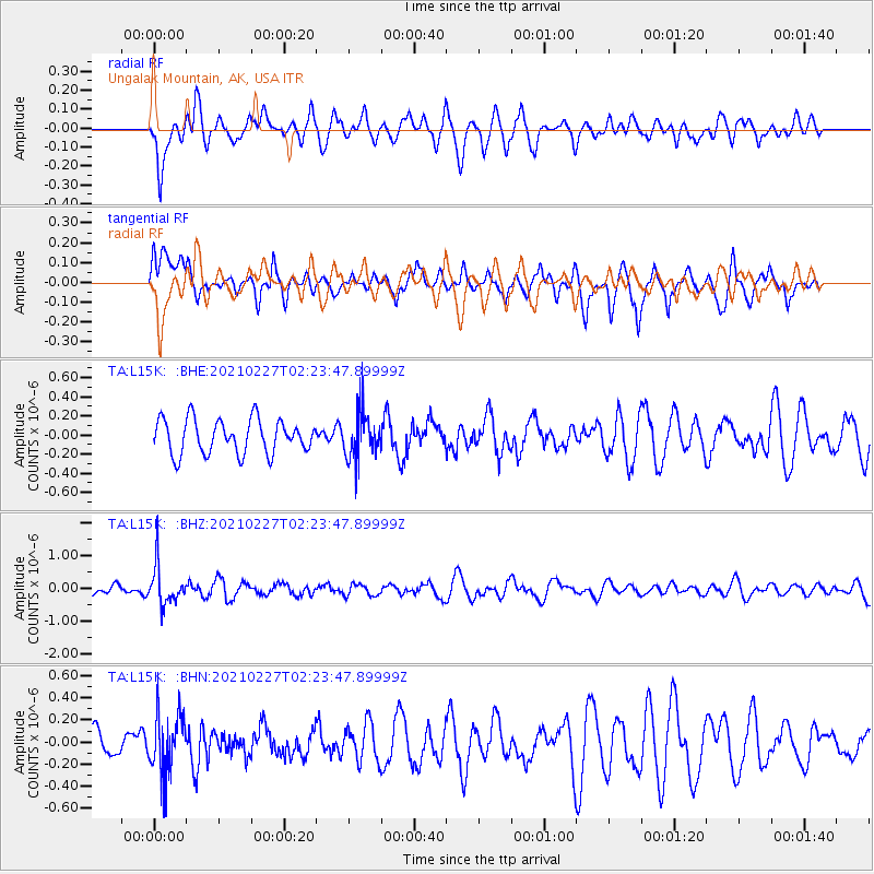
L15K Ungalak Mountain, AK, USA - Earthquake Result Viewer
*The percent match for this event was below the threshold and hence no stack was calculated.
| Earthquake location: |
Fiji Islands Region |
| Earthquake latitude/longitude: |
-18.5/-177.9 |
| Earthquake time(UTC): |
2021/02/27 (058) 02:13:01 GMT |
| Earthquake Depth: |
554 km |
| Earthquake Magnitude: |
5.6 mww |
| Earthquake Catalog/Contributor: |
NEIC PDE/us |
|
| Network: |
TA USArray Transportable Network (new EarthScope stations) |
| Station: |
L15K Ungalak Mountain, AK, USA |
| Lat/Lon: |
61.68 N/161.49 W |
| Elevation: |
219 m |
|
| Distance: |
81.0 deg |
| Az: |
7.861 deg |
| Baz: |
195.792 deg |
| Ray Param: |
$rayparam |
*The percent match for this event was below the threshold and hence was not used in the summary stack. |
|
| Radial Match: |
48.67304 % |
| Radial Bump: |
400 |
| Transverse Match: |
48.66654 % |
| Transverse Bump: |
400 |
| SOD ConfigId: |
23341671 |
| Insert Time: |
2021-03-13 03:30:46.474 +0000 |
| GWidth: |
2.5 |
| Max Bumps: |
400 |
| Tol: |
0.001 |
|
Signal To Noise
| Channel | StoN | STA | LTA |
| TA:L15K: :BHZ:20210227T02:23:47.89999Z | 2.7028644 | 6.0591003E-7 | 2.2417329E-7 |
| TA:L15K: :BHN:20210227T02:23:47.89999Z | 1.8581746 | 2.7243846E-7 | 1.4661619E-7 |
| TA:L15K: :BHE:20210227T02:23:47.89999Z | 1.3799198 | 2.461382E-7 | 1.7837138E-7 |
| Arrivals |
| Ps | |
| PpPs | |
| PsPs/PpSs | |


