You are here: Home > Network List > TX - Texas Seismological Network Stations List
> Station SN03 Snyder 3 > Earthquake Result Viewer
SN03 Snyder 3 - Earthquake Result Viewer
| Earthquake location: |
Tonga Islands |
| Earthquake latitude/longitude: |
-20.6/-173.9 |
| Earthquake time(UTC): |
2017/10/18 (291) 12:00:59 GMT |
| Earthquake Depth: |
10 km |
| Earthquake Magnitude: |
6.0 Mww |
| Earthquake Catalog/Contributor: |
NEIC PDE/us |
|
| Network: |
TX Texas Seismological Network |
| Station: |
SN03 Snyder 3 |
| Lat/Lon: |
32.92 N/100.94 W |
| Elevation: |
744 m |
|
| Distance: |
87.6 deg |
| Az: |
53.591 deg |
| Baz: |
243.698 deg |
| Ray Param: |
0.043205477 |
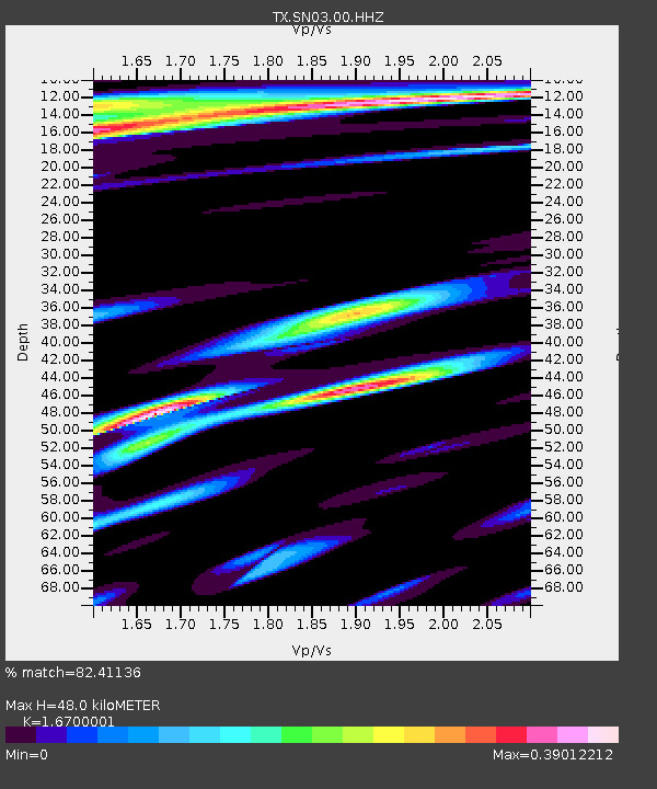
| Estimated Moho Depth: |
48.0 km |
| Estimated Crust Vp/Vs: |
1.67 |
| Assumed Crust Vp: |
6.426 km/s |
| Estimated Crust Vs: |
3.848 km/s |
| Estimated Crust Poisson's Ratio: |
0.22 |
|
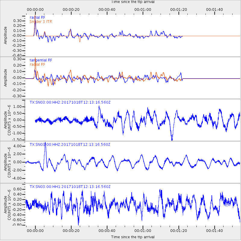
| Radial Match: |
82.41136 % |
| Radial Bump: |
400 |
| Transverse Match: |
77.97639 % |
| Transverse Bump: |
400 |
| SOD ConfigId: |
2364251 |
| Insert Time: |
2017-11-01 12:10:18.243 +0000 |
| GWidth: |
2.5 |
| Max Bumps: |
400 |
| Tol: |
0.001 |
|
Signal To Noise
| Channel | StoN | STA | LTA |
| TX:SN03:00:HHZ:20171018T12:13:16.560Z | 6.8536177 | 8.442152E-7 | 1.2317804E-7 |
| TX:SN03:00:HH1:20171018T12:13:16.560Z | 0.60142726 | 1.0760694E-7 | 1.7891928E-7 |
| TX:SN03:00:HH2:20171018T12:13:16.560Z | 2.0695217 | 2.5152332E-7 | 1.2153693E-7 |
| Arrivals |
| Ps | 5.1 SECOND |
| PpPs | 19 SECOND |
| PsPs/PpSs | 25 SECOND |


