You are here: Home > Network List > TA - USArray Transportable Network (new EarthScope stations) Stations List
> Station O17K Koliganek, Bristol Bay, AK, USA > Earthquake Result Viewer
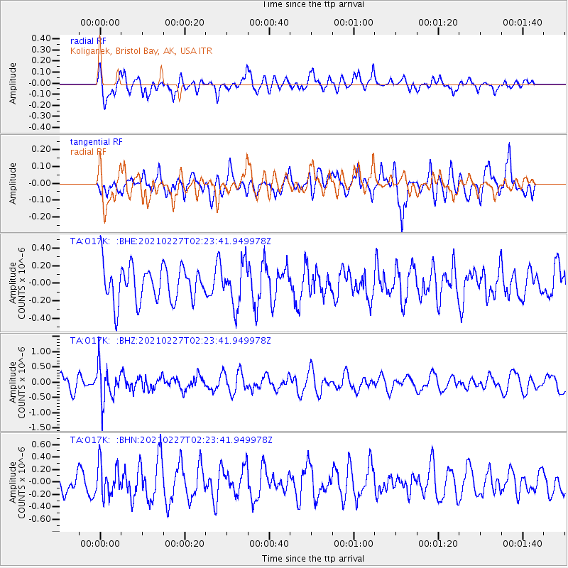
O17K Koliganek, Bristol Bay, AK, USA - Earthquake Result Viewer
*The percent match for this event was below the threshold and hence no stack was calculated.
| Earthquake location: |
Fiji Islands Region |
| Earthquake latitude/longitude: |
-18.5/-177.9 |
| Earthquake time(UTC): |
2021/02/27 (058) 02:13:01 GMT |
| Earthquake Depth: |
554 km |
| Earthquake Magnitude: |
5.6 mww |
| Earthquake Catalog/Contributor: |
NEIC PDE/us |
|
| Network: |
TA USArray Transportable Network (new EarthScope stations) |
| Station: |
O17K Koliganek, Bristol Bay, AK, USA |
| Lat/Lon: |
59.77 N/157.09 W |
| Elevation: |
156 m |
|
| Distance: |
79.8 deg |
| Az: |
10.54 deg |
| Baz: |
200.065 deg |
| Ray Param: |
$rayparam |
*The percent match for this event was below the threshold and hence was not used in the summary stack. |
|
| Radial Match: |
54.14865 % |
| Radial Bump: |
400 |
| Transverse Match: |
56.003036 % |
| Transverse Bump: |
400 |
| SOD ConfigId: |
23341671 |
| Insert Time: |
2021-03-13 03:31:01.320 +0000 |
| GWidth: |
2.5 |
| Max Bumps: |
400 |
| Tol: |
0.001 |
|
Signal To Noise
| Channel | StoN | STA | LTA |
| TA:O17K: :BHZ:20210227T02:23:41.949978Z | 2.4501746 | 5.845364E-7 | 2.385693E-7 |
| TA:O17K: :BHN:20210227T02:23:41.949978Z | 1.2233424 | 2.6734557E-7 | 2.1853698E-7 |
| TA:O17K: :BHE:20210227T02:23:41.949978Z | 1.1843915 | 2.404072E-7 | 2.0297949E-7 |
| Arrivals |
| Ps | |
| PpPs | |
| PsPs/PpSs | |


