You are here: Home > Network List > US - United States National Seismic Network Stations List
> Station BW06 Boulder Array Site 6 (Pinedale), Wyoming, USA > Earthquake Result Viewer
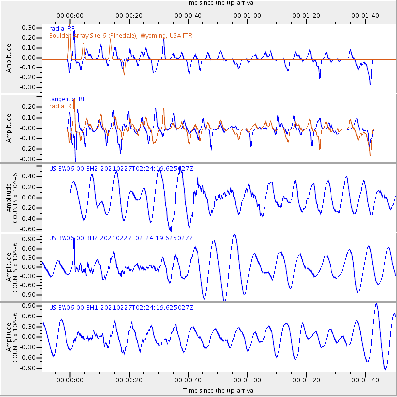
BW06 Boulder Array Site 6 (Pinedale), Wyoming, USA - Earthquake Result Viewer
*The percent match for this event was below the threshold and hence no stack was calculated.
| Earthquake location: |
Fiji Islands Region |
| Earthquake latitude/longitude: |
-18.5/-177.9 |
| Earthquake time(UTC): |
2021/02/27 (058) 02:13:01 GMT |
| Earthquake Depth: |
554 km |
| Earthquake Magnitude: |
5.6 mww |
| Earthquake Catalog/Contributor: |
NEIC PDE/us |
|
| Network: |
US United States National Seismic Network |
| Station: |
BW06 Boulder Array Site 6 (Pinedale), Wyoming, USA |
| Lat/Lon: |
42.77 N/109.56 W |
| Elevation: |
2224 m |
|
| Distance: |
87.5 deg |
| Az: |
43.257 deg |
| Baz: |
242.011 deg |
| Ray Param: |
$rayparam |
*The percent match for this event was below the threshold and hence was not used in the summary stack. |
|
| Radial Match: |
64.234726 % |
| Radial Bump: |
400 |
| Transverse Match: |
41.019417 % |
| Transverse Bump: |
350 |
| SOD ConfigId: |
23341671 |
| Insert Time: |
2021-03-13 03:32:27.652 +0000 |
| GWidth: |
2.5 |
| Max Bumps: |
400 |
| Tol: |
0.001 |
|
Signal To Noise
| Channel | StoN | STA | LTA |
| US:BW06:00:BHZ:20210227T02:24:19.625027Z | 0.9498562 | 2.7874475E-7 | 2.9345992E-7 |
| US:BW06:00:BH1:20210227T02:24:19.625027Z | 0.7287431 | 1.8297746E-7 | 2.510864E-7 |
| US:BW06:00:BH2:20210227T02:24:19.625027Z | 1.725221 | 4.2157023E-7 | 2.443572E-7 |
| Arrivals |
| Ps | |
| PpPs | |
| PsPs/PpSs | |


