You are here: Home > Network List > UW - Pacific Northwest Regional Seismic Network Stations List
> Station LTY Liberty (broad-band) > Earthquake Result Viewer
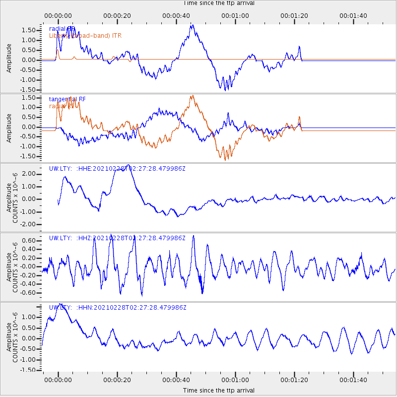
LTY Liberty (broad-band) - Earthquake Result Viewer
*The percent match for this event was below the threshold and hence no stack was calculated.
| Earthquake location: |
Near Coast Of Peru |
| Earthquake latitude/longitude: |
-17.6/-72.6 |
| Earthquake time(UTC): |
2021/02/28 (059) 02:16:03 GMT |
| Earthquake Depth: |
9.7 km |
| Earthquake Magnitude: |
5.5 mww |
| Earthquake Catalog/Contributor: |
NEIC PDE/us |
|
| Network: |
UW Pacific Northwest Regional Seismic Network |
| Station: |
LTY Liberty (broad-band) |
| Lat/Lon: |
47.26 N/120.66 W |
| Elevation: |
970 m |
|
| Distance: |
77.6 deg |
| Az: |
328.739 deg |
| Baz: |
133.386 deg |
| Ray Param: |
$rayparam |
*The percent match for this event was below the threshold and hence was not used in the summary stack. |
|
| Radial Match: |
46.35847 % |
| Radial Bump: |
400 |
| Transverse Match: |
49.133995 % |
| Transverse Bump: |
400 |
| SOD ConfigId: |
23341671 |
| Insert Time: |
2021-03-14 03:33:55.249 +0000 |
| GWidth: |
2.5 |
| Max Bumps: |
400 |
| Tol: |
0.001 |
|
Signal To Noise
| Channel | StoN | STA | LTA |
| UW:LTY: :HHZ:20210228T02:27:28.479986Z | 0.9350841 | 1.7285187E-7 | 1.8485169E-7 |
| UW:LTY: :HHN:20210228T02:27:28.479986Z | 4.0322056 | 2.2428935E-6 | 5.5624486E-7 |
| UW:LTY: :HHE:20210228T02:27:28.479986Z | 1.5246755 | 1.5797157E-6 | 1.0360997E-6 |
| Arrivals |
| Ps | |
| PpPs | |
| PsPs/PpSs | |


