You are here: Home > Network List > US - United States National Seismic Network Stations List
> Station DGMT Dagmar, Montana, USA > Earthquake Result Viewer
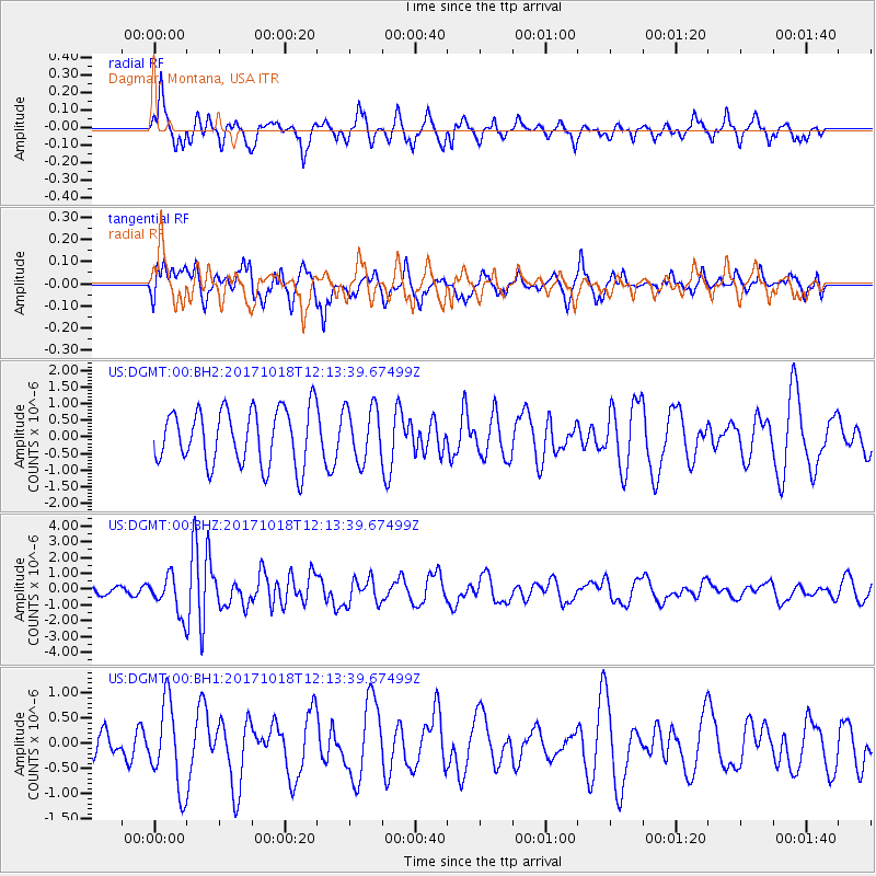
DGMT Dagmar, Montana, USA - Earthquake Result Viewer
*The percent match for this event was below the threshold and hence no stack was calculated.
| Earthquake location: |
Tonga Islands |
| Earthquake latitude/longitude: |
-20.6/-173.9 |
| Earthquake time(UTC): |
2017/10/18 (291) 12:00:59 GMT |
| Earthquake Depth: |
10 km |
| Earthquake Magnitude: |
6.0 Mww |
| Earthquake Catalog/Contributor: |
NEIC PDE/us |
|
| Network: |
US United States National Seismic Network |
| Station: |
DGMT Dagmar, Montana, USA |
| Lat/Lon: |
48.47 N/104.20 W |
| Elevation: |
0.0 m |
|
| Distance: |
92.6 deg |
| Az: |
38.667 deg |
| Baz: |
241.586 deg |
| Ray Param: |
$rayparam |
*The percent match for this event was below the threshold and hence was not used in the summary stack. |
|
| Radial Match: |
58.509083 % |
| Radial Bump: |
299 |
| Transverse Match: |
49.067307 % |
| Transverse Bump: |
372 |
| SOD ConfigId: |
2364251 |
| Insert Time: |
2017-11-01 12:11:52.953 +0000 |
| GWidth: |
2.5 |
| Max Bumps: |
400 |
| Tol: |
0.001 |
|
Signal To Noise
| Channel | StoN | STA | LTA |
| US:DGMT:00:BHZ:20171018T12:13:39.67499Z | 4.51531 | 1.1892881E-6 | 2.6339018E-7 |
| US:DGMT:00:BH1:20171018T12:13:39.67499Z | 4.1644607 | 8.3997264E-7 | 2.0170023E-7 |
| US:DGMT:00:BH2:20171018T12:13:39.67499Z | 0.9746 | 8.108631E-7 | 8.319958E-7 |
| Arrivals |
| Ps | |
| PpPs | |
| PsPs/PpSs | |


