You are here: Home > Network List > US - United States National Seismic Network Stations List
> Station MSO Missoula, Montana, USA > Earthquake Result Viewer
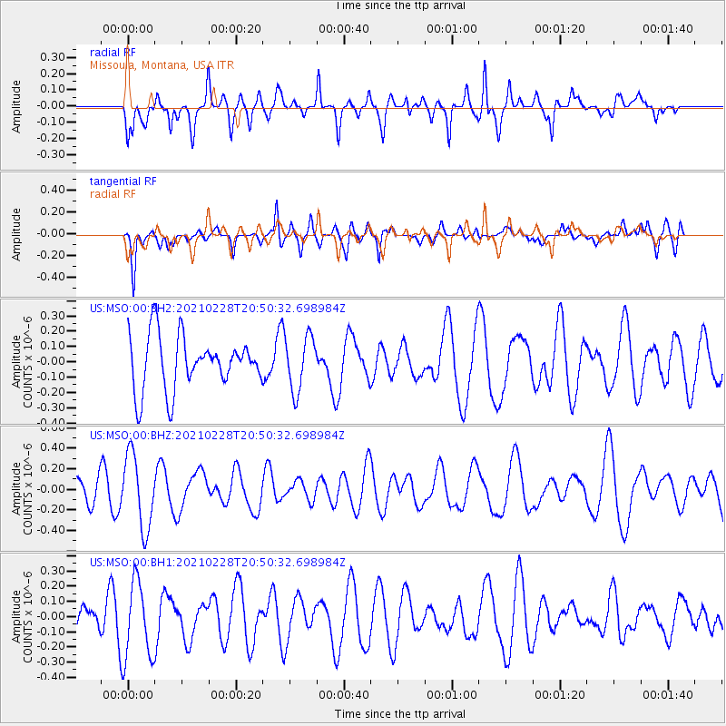
MSO Missoula, Montana, USA - Earthquake Result Viewer
*The percent match for this event was below the threshold and hence no stack was calculated.
| Earthquake location: |
Southeast Of Loyalty Islands |
| Earthquake latitude/longitude: |
-22.7/172.4 |
| Earthquake time(UTC): |
2021/02/28 (059) 20:37:38 GMT |
| Earthquake Depth: |
10 km |
| Earthquake Magnitude: |
5.5 mww |
| Earthquake Catalog/Contributor: |
NEIC PDE/us |
|
| Network: |
US United States National Seismic Network |
| Station: |
MSO Missoula, Montana, USA |
| Lat/Lon: |
46.83 N/113.94 W |
| Elevation: |
1264 m |
|
| Distance: |
95.8 deg |
| Az: |
41.475 deg |
| Baz: |
242.986 deg |
| Ray Param: |
$rayparam |
*The percent match for this event was below the threshold and hence was not used in the summary stack. |
|
| Radial Match: |
57.289783 % |
| Radial Bump: |
396 |
| Transverse Match: |
73.66597 % |
| Transverse Bump: |
400 |
| SOD ConfigId: |
23341671 |
| Insert Time: |
2021-03-14 21:49:41.383 +0000 |
| GWidth: |
2.5 |
| Max Bumps: |
400 |
| Tol: |
0.001 |
|
Signal To Noise
| Channel | StoN | STA | LTA |
| US:MSO:00:BHZ:20210228T20:50:32.698984Z | 2.1564705 | 3.614933E-7 | 1.6763192E-7 |
| US:MSO:00:BH1:20210228T20:50:32.698984Z | 2.7923865 | 2.5287306E-7 | 9.055805E-8 |
| US:MSO:00:BH2:20210228T20:50:32.698984Z | 1.0200853 | 1.7736639E-7 | 1.7387406E-7 |
| Arrivals |
| Ps | |
| PpPs | |
| PsPs/PpSs | |


