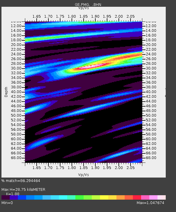
PMG IRIS/GEOFON/PACIFIC21 Station Port Moresby, PNG - Earthquake Result Viewer

Earthquake location: Kermadec Islands, New Zealand
Earthquake latitude/longitude: -29.5/-177.1
Earthquake time(UTC): 1993/09/13 (256) 12:37:53 GMT
Earthquake Depth: 32 km
Earthquake Magnitude: 5.7 MB, 6.1 MS, 6.2 UNKNOWN, 6.2 MW
Earthquake Catalog/Contributor: WHDF/NEIC
Network: GE GEOFON
Station: PMG IRIS/GEOFON/PACIFIC21 Station Port Moresby, PNG
Lat/Lon: 9.41 S/147.15 E
Elevation: 67 m
Distance: 38.9 deg
Az: 293.563 deg
Baz: 125.928 deg
Ray Param: 0.07522558
Estimated Moho Depth: 28.75 km
Estimated Crust Vp/Vs: 1.88
Assumed Crust Vp: 6.122 km/s
Estimated Crust Vs: 3.256 km/s
Estimated Crust Poisson's Ratio: 0.30
Radial Match: 86.294464 %
Radial Bump: 400
Transverse Match: 65.75025 %
Transverse Bump: 400
SOD ConfigId: 16938
Insert Time: 2010-03-09 05:44:57.311 +0000
GWidth: 2.5
Max Bumps: 400
Tol: 0.001

Signal To Noise

ChannelStoNSTALTA
GE:PMG: :BHN:19930913T12:44:45.717987Z3.13023783.5931586E-71.14788676E-7
GE:PMG: :BHE:19930913T12:44:45.717987Z3.41143543.9295526E-71.1518766E-7
GE:PMG: :BHZ:19930913T12:44:45.717987Z6.0656979.51283E-71.5682996E-7
Arrivals
Ps4.4 SECOND
PpPs13 SECOND
PsPs/PpSs17 SECOND