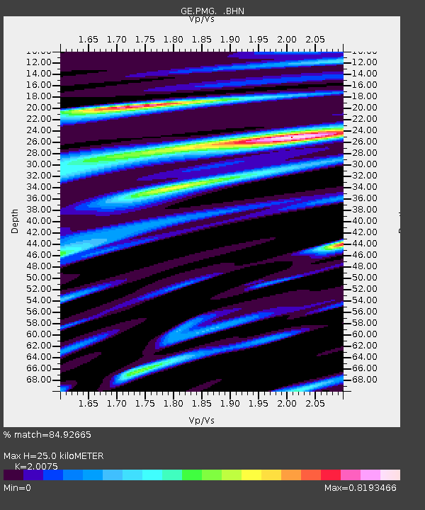
PMG IRIS/GEOFON/PACIFIC21 Station Port Moresby, PNG - Earthquake Result Viewer

Earthquake location: Off East Coast Of Honshu, Japan
Earthquake latitude/longitude: 40.6/143.8
Earthquake time(UTC): 1994/04/08 (098) 01:10:41 GMT
Earthquake Depth: 21 km
Earthquake Magnitude: 6.0 MB, 6.2 MS, 5.8 UNKNOWN, 6.4 MW
Earthquake Catalog/Contributor: WHDF/NEIC
Network: GE GEOFON
Station: PMG IRIS/GEOFON/PACIFIC21 Station Port Moresby, PNG
Lat/Lon: 9.41 S/147.15 E
Elevation: 67 m
Distance: 49.8 deg
Az: 175.607 deg
Baz: 356.609 deg
Ray Param: 0.068436414
Estimated Moho Depth: 25.0 km
Estimated Crust Vp/Vs: 2.01
Assumed Crust Vp: 6.122 km/s
Estimated Crust Vs: 3.05 km/s
Estimated Crust Poisson's Ratio: 0.33
Radial Match: 84.92665 %
Radial Bump: 400
Transverse Match: 66.136215 %
Transverse Bump: 400
SOD ConfigId: 16938
Insert Time: 2010-03-09 05:45:09.652 +0000
GWidth: 2.5
Max Bumps: 400
Tol: 0.001

Signal To Noise

ChannelStoNSTALTA
GE:PMG: :BHN:19940408T01:19:02.003015Z1.54971872.838787E-71.8318079E-7
GE:PMG: :BHE:19940408T01:19:02.003015Z0.802774971.408752E-71.754853E-7
GE:PMG: :BHZ:19940408T01:19:02.003015Z4.63051187.6059547E-71.6425732E-7
Arrivals
Ps4.3 SECOND
PpPs12 SECOND
PsPs/PpSs16 SECOND