You are here: Home > Network List > TA - USArray Transportable Network (new EarthScope stations) Stations List
> Station I17K Unalakleet, AK, USA > Earthquake Result Viewer
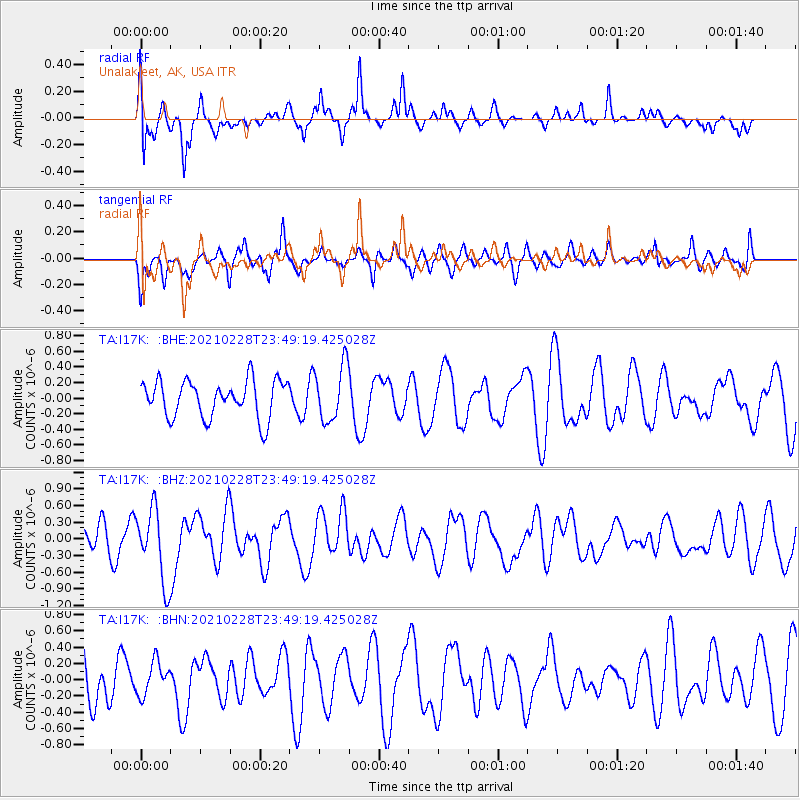
I17K Unalakleet, AK, USA - Earthquake Result Viewer
*The percent match for this event was below the threshold and hence no stack was calculated.
| Earthquake location: |
Vanuatu Islands |
| Earthquake latitude/longitude: |
-17.7/167.5 |
| Earthquake time(UTC): |
2021/02/28 (059) 23:37:15 GMT |
| Earthquake Depth: |
10 km |
| Earthquake Magnitude: |
5.8 mww |
| Earthquake Catalog/Contributor: |
NEIC PDE/us |
|
| Network: |
TA USArray Transportable Network (new EarthScope stations) |
| Station: |
I17K Unalakleet, AK, USA |
| Lat/Lon: |
63.89 N/160.70 W |
| Elevation: |
105 m |
|
| Distance: |
85.0 deg |
| Az: |
13.546 deg |
| Baz: |
210.298 deg |
| Ray Param: |
$rayparam |
*The percent match for this event was below the threshold and hence was not used in the summary stack. |
|
| Radial Match: |
59.155098 % |
| Radial Bump: |
395 |
| Transverse Match: |
48.05416 % |
| Transverse Bump: |
372 |
| SOD ConfigId: |
23341671 |
| Insert Time: |
2021-03-15 00:47:21.190 +0000 |
| GWidth: |
2.5 |
| Max Bumps: |
400 |
| Tol: |
0.001 |
|
Signal To Noise
| Channel | StoN | STA | LTA |
| TA:I17K: :BHZ:20210228T23:49:19.425028Z | 2.6573584 | 6.5749254E-7 | 2.4742337E-7 |
| TA:I17K: :BHN:20210228T23:49:19.425028Z | 0.50270385 | 2.0884808E-7 | 4.1544953E-7 |
| TA:I17K: :BHE:20210228T23:49:19.425028Z | 1.5056174 | 3.5797444E-7 | 2.3775924E-7 |
| Arrivals |
| Ps | |
| PpPs | |
| PsPs/PpSs | |


