You are here: Home > Network List > US - United States National Seismic Network Stations List
> Station OGNE Ogallala, Nebraska, USA > Earthquake Result Viewer
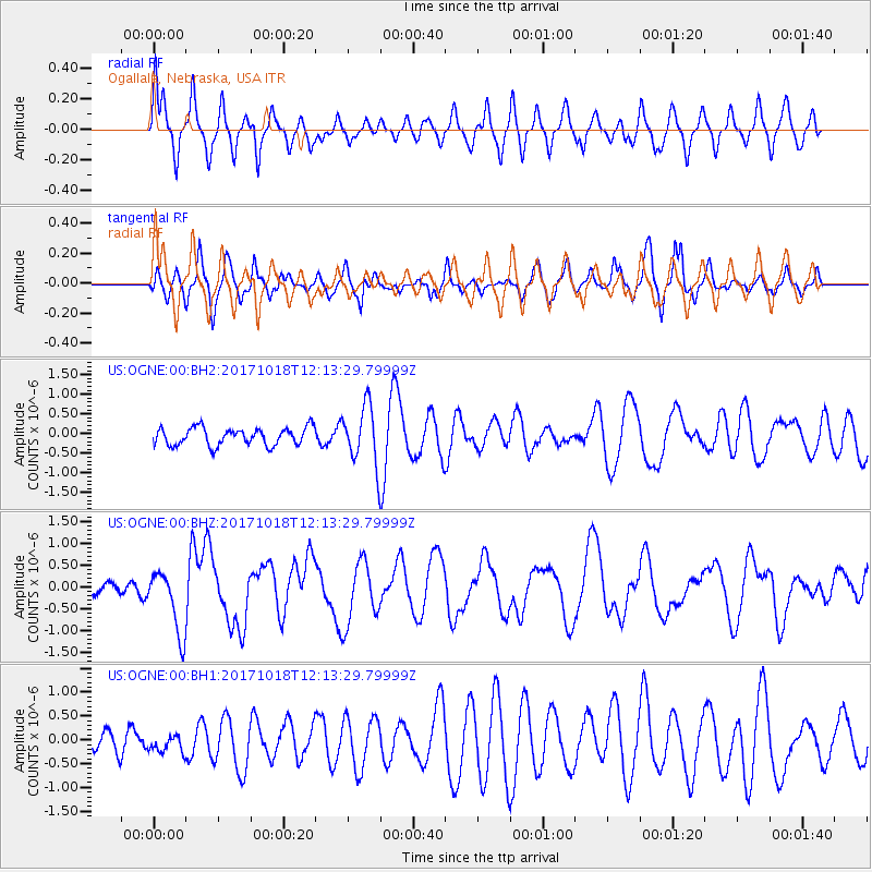
OGNE Ogallala, Nebraska, USA - Earthquake Result Viewer
*The percent match for this event was below the threshold and hence no stack was calculated.
| Earthquake location: |
Tonga Islands |
| Earthquake latitude/longitude: |
-20.6/-173.9 |
| Earthquake time(UTC): |
2017/10/18 (291) 12:00:59 GMT |
| Earthquake Depth: |
10 km |
| Earthquake Magnitude: |
6.0 Mww |
| Earthquake Catalog/Contributor: |
NEIC PDE/us |
|
| Network: |
US United States National Seismic Network |
| Station: |
OGNE Ogallala, Nebraska, USA |
| Lat/Lon: |
40.95 N/102.03 W |
| Elevation: |
1054 m |
|
| Distance: |
90.4 deg |
| Az: |
46.045 deg |
| Baz: |
242.913 deg |
| Ray Param: |
$rayparam |
*The percent match for this event was below the threshold and hence was not used in the summary stack. |
|
| Radial Match: |
59.487453 % |
| Radial Bump: |
400 |
| Transverse Match: |
38.191666 % |
| Transverse Bump: |
388 |
| SOD ConfigId: |
2364251 |
| Insert Time: |
2017-11-01 12:12:49.910 +0000 |
| GWidth: |
2.5 |
| Max Bumps: |
400 |
| Tol: |
0.001 |
|
Signal To Noise
| Channel | StoN | STA | LTA |
| US:OGNE:00:BHZ:20171018T12:13:29.79999Z | 4.590689 | 7.275832E-7 | 1.5849108E-7 |
| US:OGNE:00:BH1:20171018T12:13:29.79999Z | 0.44333395 | 2.0406844E-7 | 4.603041E-7 |
| US:OGNE:00:BH2:20171018T12:13:29.79999Z | 3.3143227 | 7.4249385E-7 | 2.2402583E-7 |
| Arrivals |
| Ps | |
| PpPs | |
| PsPs/PpSs | |


