You are here: Home > Network List > GE - GEOFON Stations List
> Station PMG IRIS/GEOFON/PACIFIC21 Station Port Moresby, PNG > Earthquake Result Viewer
PMG IRIS/GEOFON/PACIFIC21 Station Port Moresby, PNG - Earthquake Result Viewer
| Earthquake location: |
Fiji Islands Region |
| Earthquake latitude/longitude: |
-15.1/-177.6 |
| Earthquake time(UTC): |
1994/04/02 (092) 15:34:44 GMT |
| Earthquake Depth: |
354 km |
| Earthquake Magnitude: |
5.5 MB |
| Earthquake Catalog/Contributor: |
WHDF/NEIC |
|
| Network: |
GE GEOFON |
| Station: |
PMG IRIS/GEOFON/PACIFIC21 Station Port Moresby, PNG |
| Lat/Lon: |
9.41 S/147.15 E |
| Elevation: |
67 m |
|
| Distance: |
34.9 deg |
| Az: |
275.178 deg |
| Baz: |
102.865 deg |
| Ray Param: |
0.076046415 |
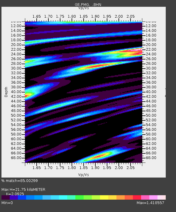
| Estimated Moho Depth: |
21.75 km |
| Estimated Crust Vp/Vs: |
2.09 |
| Assumed Crust Vp: |
6.122 km/s |
| Estimated Crust Vs: |
2.926 km/s |
| Estimated Crust Poisson's Ratio: |
0.35 |
|
| Radial Match: |
85.00299 % |
| Radial Bump: |
400 |
| Transverse Match: |
79.526665 % |
| Transverse Bump: |
400 |
| SOD ConfigId: |
17000 |
| Insert Time: |
2010-03-09 05:45:30.669 +0000 |
| GWidth: |
2.5 |
| Max Bumps: |
400 |
| Tol: |
0.001 |
|

Signal To Noise
| Channel | StoN | STA | LTA |
| GE:PMG: :BHN:19940402T15:40:33.905011Z | 1.6439191 | 2.1357707E-7 | 1.2991946E-7 |
| GE:PMG: :BHE:19940402T15:40:33.905011Z | 6.07131 | 7.815325E-7 | 1.287255E-7 |
| GE:PMG: :BHZ:19940402T15:40:33.905011Z | 13.238041 | 1.830646E-6 | 1.3828678E-7 |
| Arrivals |
| Ps | 4.1 SECOND |
| PpPs | 10 SECOND |
| PsPs/PpSs | 14 SECOND |


