You are here: Home > Network List > TA - USArray Transportable Network (new EarthScope stations) Stations List
> Station E20K Nigu River, AK, USA > Earthquake Result Viewer
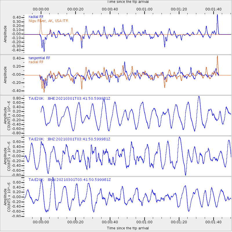
E20K Nigu River, AK, USA - Earthquake Result Viewer
*The percent match for this event was below the threshold and hence no stack was calculated.
| Earthquake location: |
Vanuatu Islands |
| Earthquake latitude/longitude: |
-13.2/166.7 |
| Earthquake time(UTC): |
2021/03/01 (060) 03:29:49 GMT |
| Earthquake Depth: |
51 km |
| Earthquake Magnitude: |
5.4 Mww |
| Earthquake Catalog/Contributor: |
NEIC PDE/us |
|
| Network: |
TA USArray Transportable Network (new EarthScope stations) |
| Station: |
E20K Nigu River, AK, USA |
| Lat/Lon: |
68.26 N/156.19 W |
| Elevation: |
866 m |
|
| Distance: |
85.5 deg |
| Az: |
13.044 deg |
| Baz: |
216.159 deg |
| Ray Param: |
$rayparam |
*The percent match for this event was below the threshold and hence was not used in the summary stack. |
|
| Radial Match: |
52.131878 % |
| Radial Bump: |
376 |
| Transverse Match: |
64.635605 % |
| Transverse Bump: |
400 |
| SOD ConfigId: |
23341671 |
| Insert Time: |
2021-03-15 04:40:27.547 +0000 |
| GWidth: |
2.5 |
| Max Bumps: |
400 |
| Tol: |
0.001 |
|
Signal To Noise
| Channel | StoN | STA | LTA |
| TA:E20K: :BHZ:20210301T03:41:50.599981Z | 1.5258479 | 4.448395E-7 | 2.9153594E-7 |
| TA:E20K: :BHN:20210301T03:41:50.599981Z | 2.6839452 | 4.9037885E-7 | 1.8270822E-7 |
| TA:E20K: :BHE:20210301T03:41:50.599981Z | 1.2322383 | 4.320952E-7 | 3.5065878E-7 |
| Arrivals |
| Ps | |
| PpPs | |
| PsPs/PpSs | |


