You are here: Home > Network List > UU - University of Utah Regional Network Stations List
> Station FOR1 Milford Southwest, UT, USA > Earthquake Result Viewer
FOR1 Milford Southwest, UT, USA - Earthquake Result Viewer
| Earthquake location: |
Tonga Islands |
| Earthquake latitude/longitude: |
-20.6/-173.9 |
| Earthquake time(UTC): |
2017/10/18 (291) 12:00:59 GMT |
| Earthquake Depth: |
10 km |
| Earthquake Magnitude: |
6.0 Mww |
| Earthquake Catalog/Contributor: |
NEIC PDE/us |
|
| Network: |
UU University of Utah Regional Network |
| Station: |
FOR1 Milford Southwest, UT, USA |
| Lat/Lon: |
38.37 N/113.09 W |
| Elevation: |
1642 m |
|
| Distance: |
81.8 deg |
| Az: |
43.892 deg |
| Baz: |
235.721 deg |
| Ray Param: |
0.047349583 |
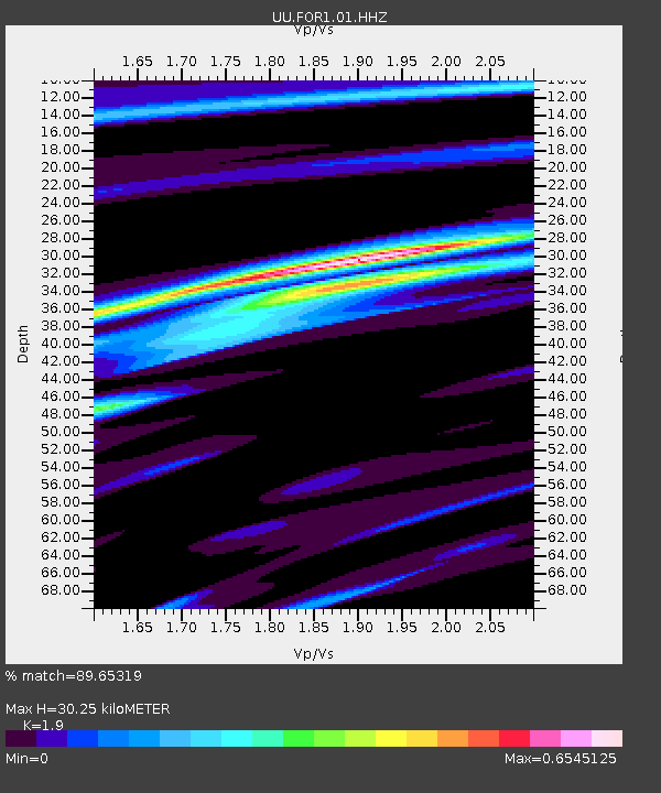
| Estimated Moho Depth: |
30.25 km |
| Estimated Crust Vp/Vs: |
1.90 |
| Assumed Crust Vp: |
6.276 km/s |
| Estimated Crust Vs: |
3.303 km/s |
| Estimated Crust Poisson's Ratio: |
0.31 |
|
| Radial Match: |
89.65319 % |
| Radial Bump: |
318 |
| Transverse Match: |
65.73364 % |
| Transverse Bump: |
400 |
| SOD ConfigId: |
2364251 |
| Insert Time: |
2017-11-01 12:13:19.106 +0000 |
| GWidth: |
2.5 |
| Max Bumps: |
400 |
| Tol: |
0.001 |
|

Signal To Noise
| Channel | StoN | STA | LTA |
| UU:FOR1:01:HHZ:20171018T12:12:47.260012Z | 7.06885 | 2.7703862E-8 | 3.919147E-9 |
| UU:FOR1:01:HHN:20171018T12:12:47.260012Z | 1.3450913 | 7.1351063E-9 | 5.3045515E-9 |
| UU:FOR1:01:HHE:20171018T12:12:47.260012Z | 2.8918998 | 1.0769561E-8 | 3.724044E-9 |
| Arrivals |
| Ps | 4.4 SECOND |
| PpPs | 14 SECOND |
| PsPs/PpSs | 18 SECOND |


