You are here: Home > Network List > GE - GEOFON Stations List
> Station PMG IRIS/GEOFON/PACIFIC21 Station Port Moresby, PNG > Earthquake Result Viewer
PMG IRIS/GEOFON/PACIFIC21 Station Port Moresby, PNG - Earthquake Result Viewer
| Earthquake location: |
Myanmar-India Border Region |
| Earthquake latitude/longitude: |
25.0/95.3 |
| Earthquake time(UTC): |
1995/05/06 (126) 01:59:07 GMT |
| Earthquake Depth: |
122 km |
| Earthquake Magnitude: |
6.4 MB, 6.5 UNKNOWN, 6.4 MW |
| Earthquake Catalog/Contributor: |
WHDF/NEIC |
|
| Network: |
GE GEOFON |
| Station: |
PMG IRIS/GEOFON/PACIFIC21 Station Port Moresby, PNG |
| Lat/Lon: |
9.41 S/147.15 E |
| Elevation: |
67 m |
|
| Distance: |
61.0 deg |
| Az: |
117.501 deg |
| Baz: |
305.349 deg |
| Ray Param: |
0.060819425 |
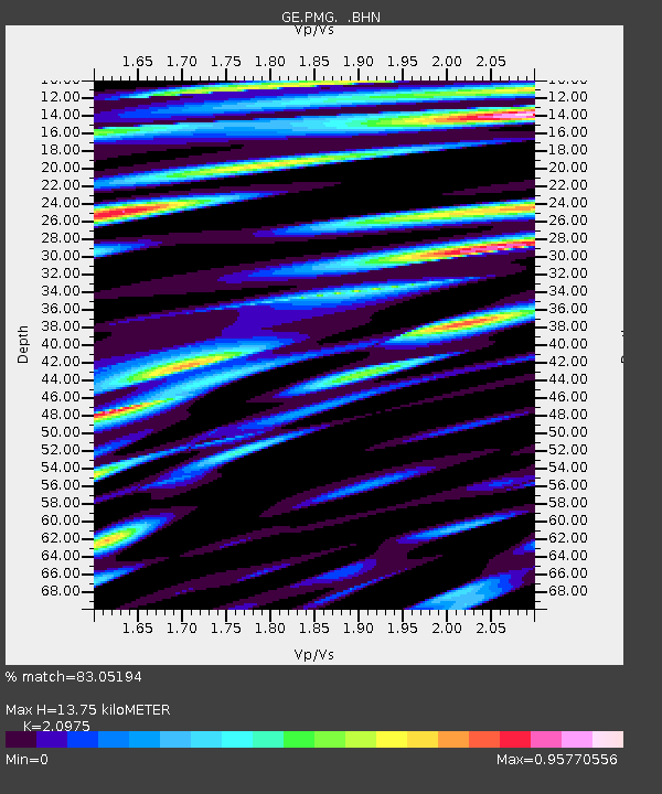
| Estimated Moho Depth: |
13.75 km |
| Estimated Crust Vp/Vs: |
2.10 |
| Assumed Crust Vp: |
6.122 km/s |
| Estimated Crust Vs: |
2.919 km/s |
| Estimated Crust Poisson's Ratio: |
0.35 |
|
| Radial Match: |
83.05194 % |
| Radial Bump: |
400 |
| Transverse Match: |
84.36349 % |
| Transverse Bump: |
400 |
| SOD ConfigId: |
6273 |
| Insert Time: |
2010-03-09 05:46:03.309 +0000 |
| GWidth: |
2.5 |
| Max Bumps: |
400 |
| Tol: |
0.001 |
|

Signal To Noise
| Channel | StoN | STA | LTA |
| GE:PMG: :BHN:19950506T02:08:37.203003Z | 5.736531 | 7.601124E-7 | 1.3250384E-7 |
| GE:PMG: :BHE:19950506T02:08:37.203003Z | 3.3957207 | 5.448342E-7 | 1.604473E-7 |
| GE:PMG: :BHZ:19950506T02:08:37.203003Z | 16.521677 | 2.0117113E-6 | 1.2176193E-7 |
| Arrivals |
| Ps | 2.6 SECOND |
| PpPs | 6.7 SECOND |
| PsPs/PpSs | 9.3 SECOND |


