You are here: Home > Network List > US - United States National Seismic Network Stations List
> Station AMTX Amarillo, Texas, USA > Earthquake Result Viewer
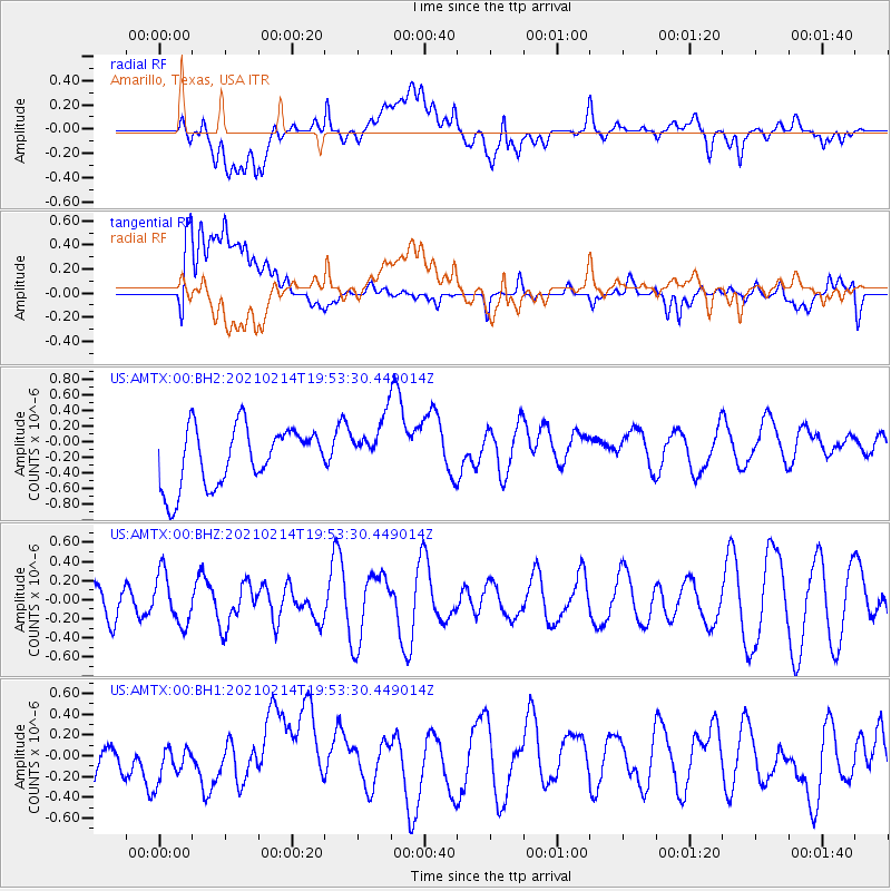
AMTX Amarillo, Texas, USA - Earthquake Result Viewer
*The percent match for this event was below the threshold and hence no stack was calculated.
| Earthquake location: |
Off Coast Of Ecuador |
| Earthquake latitude/longitude: |
1.0/-85.2 |
| Earthquake time(UTC): |
2021/02/14 (045) 19:46:53 GMT |
| Earthquake Depth: |
31 km |
| Earthquake Magnitude: |
4.6 mb |
| Earthquake Catalog/Contributor: |
NEIC PDE/us |
|
| Network: |
US United States National Seismic Network |
| Station: |
AMTX Amarillo, Texas, USA |
| Lat/Lon: |
34.53 N/101.41 W |
| Elevation: |
1010 m |
|
| Distance: |
36.6 deg |
| Az: |
337.286 deg |
| Baz: |
152.12 deg |
| Ray Param: |
$rayparam |
*The percent match for this event was below the threshold and hence was not used in the summary stack. |
|
| Radial Match: |
43.75299 % |
| Radial Bump: |
400 |
| Transverse Match: |
51.85794 % |
| Transverse Bump: |
400 |
| SOD ConfigId: |
23341671 |
| Insert Time: |
2021-03-15 14:01:21.508 +0000 |
| GWidth: |
2.5 |
| Max Bumps: |
400 |
| Tol: |
0.001 |
|
Signal To Noise
| Channel | StoN | STA | LTA |
| US:AMTX:00:BHZ:20210214T19:53:30.449014Z | 1.5199928 | 2.61014E-7 | 1.7172054E-7 |
| US:AMTX:00:BH1:20210214T19:53:30.449014Z | 0.84943306 | 1.9138865E-7 | 2.253134E-7 |
| US:AMTX:00:BH2:20210214T19:53:30.449014Z | 0.8151238 | 3.232598E-7 | 3.9657758E-7 |
| Arrivals |
| Ps | |
| PpPs | |
| PsPs/PpSs | |


