You are here: Home > Network List > UW - Pacific Northwest Regional Seismic Network Stations List
> Station HOOD Mt Hood Meadows, OR CREST BB SMO > Earthquake Result Viewer
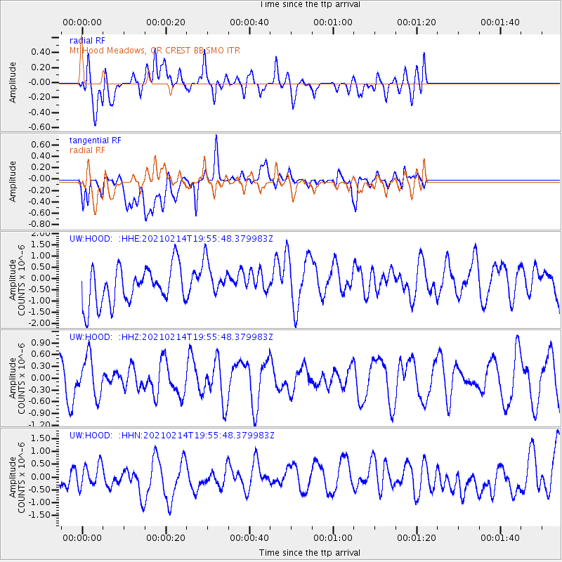
HOOD Mt Hood Meadows, OR CREST BB SMO - Earthquake Result Viewer
*The percent match for this event was below the threshold and hence no stack was calculated.
| Earthquake location: |
Off Coast Of Ecuador |
| Earthquake latitude/longitude: |
1.0/-85.2 |
| Earthquake time(UTC): |
2021/02/14 (045) 19:46:53 GMT |
| Earthquake Depth: |
31 km |
| Earthquake Magnitude: |
4.6 mb |
| Earthquake Catalog/Contributor: |
NEIC PDE/us |
|
| Network: |
UW Pacific Northwest Regional Seismic Network |
| Station: |
HOOD Mt Hood Meadows, OR CREST BB SMO |
| Lat/Lon: |
45.32 N/121.65 W |
| Elevation: |
1520 m |
|
| Distance: |
54.6 deg |
| Az: |
329.04 deg |
| Baz: |
133.192 deg |
| Ray Param: |
$rayparam |
*The percent match for this event was below the threshold and hence was not used in the summary stack. |
|
| Radial Match: |
44.87878 % |
| Radial Bump: |
400 |
| Transverse Match: |
56.63241 % |
| Transverse Bump: |
400 |
| SOD ConfigId: |
23341671 |
| Insert Time: |
2021-03-15 14:02:20.258 +0000 |
| GWidth: |
2.5 |
| Max Bumps: |
400 |
| Tol: |
0.001 |
|
Signal To Noise
| Channel | StoN | STA | LTA |
| UW:HOOD: :HHZ:20210214T19:55:48.379983Z | 0.9007227 | 5.142036E-7 | 5.7087897E-7 |
| UW:HOOD: :HHN:20210214T19:55:48.379983Z | 0.78492707 | 4.327541E-7 | 5.513303E-7 |
| UW:HOOD: :HHE:20210214T19:55:48.379983Z | 1.0224289 | 8.4666055E-7 | 8.280875E-7 |
| Arrivals |
| Ps | |
| PpPs | |
| PsPs/PpSs | |


