You are here: Home > Network List > GE - GEOFON Stations List
> Station PMG IRIS/GEOFON/PACIFIC21 Station Port Moresby, PNG > Earthquake Result Viewer
PMG IRIS/GEOFON/PACIFIC21 Station Port Moresby, PNG - Earthquake Result Viewer
| Earthquake location: |
Eastern Sea Of Japan |
| Earthquake latitude/longitude: |
43.2/138.9 |
| Earthquake time(UTC): |
1996/12/22 (357) 14:53:27 GMT |
| Earthquake Depth: |
227 km |
| Earthquake Magnitude: |
6.0 MB, 6.5 UNKNOWN, 6.5 MW |
| Earthquake Catalog/Contributor: |
WHDF/NEIC |
|
| Network: |
GE GEOFON |
| Station: |
PMG IRIS/GEOFON/PACIFIC21 Station Port Moresby, PNG |
| Lat/Lon: |
9.41 S/147.15 E |
| Elevation: |
67 m |
|
| Distance: |
52.9 deg |
| Az: |
169.794 deg |
| Baz: |
352.456 deg |
| Ray Param: |
0.06562986 |
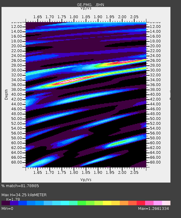
| Estimated Moho Depth: |
34.25 km |
| Estimated Crust Vp/Vs: |
1.78 |
| Assumed Crust Vp: |
6.122 km/s |
| Estimated Crust Vs: |
3.439 km/s |
| Estimated Crust Poisson's Ratio: |
0.27 |
|
| Radial Match: |
81.78985 % |
| Radial Bump: |
400 |
| Transverse Match: |
71.58069 % |
| Transverse Bump: |
400 |
| SOD ConfigId: |
6273 |
| Insert Time: |
2010-03-09 05:46:19.730 +0000 |
| GWidth: |
2.5 |
| Max Bumps: |
400 |
| Tol: |
0.001 |
|

Signal To Noise
| Channel | StoN | STA | LTA |
| GE:PMG: :BHN:19961222T15:01:49.515009Z | 7.539137 | 3.1307677E-6 | 4.1526874E-7 |
| GE:PMG: :BHE:19961222T15:01:49.515009Z | 3.1906533 | 1.0177714E-6 | 3.189853E-7 |
| GE:PMG: :BHZ:19961222T15:01:49.515009Z | 16.593729 | 6.426296E-6 | 3.8727256E-7 |
| Arrivals |
| Ps | 4.6 SECOND |
| PpPs | 15 SECOND |
| PsPs/PpSs | 19 SECOND |


