You are here: Home > Network List > GE - GEOFON Stations List
> Station PMG IRIS/GEOFON/PACIFIC21 Station Port Moresby, PNG > Earthquake Result Viewer
PMG IRIS/GEOFON/PACIFIC21 Station Port Moresby, PNG - Earthquake Result Viewer
| Earthquake location: |
Kuril Islands |
| Earthquake latitude/longitude: |
45.3/149.9 |
| Earthquake time(UTC): |
1996/02/07 (038) 21:36:45 GMT |
| Earthquake Depth: |
33 km |
| Earthquake Magnitude: |
6.3 MB, 7.0 MS, 7.2 UNKNOWN, 7.1 MW |
| Earthquake Catalog/Contributor: |
WHDF/NEIC |
|
| Network: |
GE GEOFON |
| Station: |
PMG IRIS/GEOFON/PACIFIC21 Station Port Moresby, PNG |
| Lat/Lon: |
9.41 S/147.15 E |
| Elevation: |
67 m |
|
| Distance: |
54.5 deg |
| Az: |
183.338 deg |
| Baz: |
2.386 deg |
| Ray Param: |
0.06533128 |
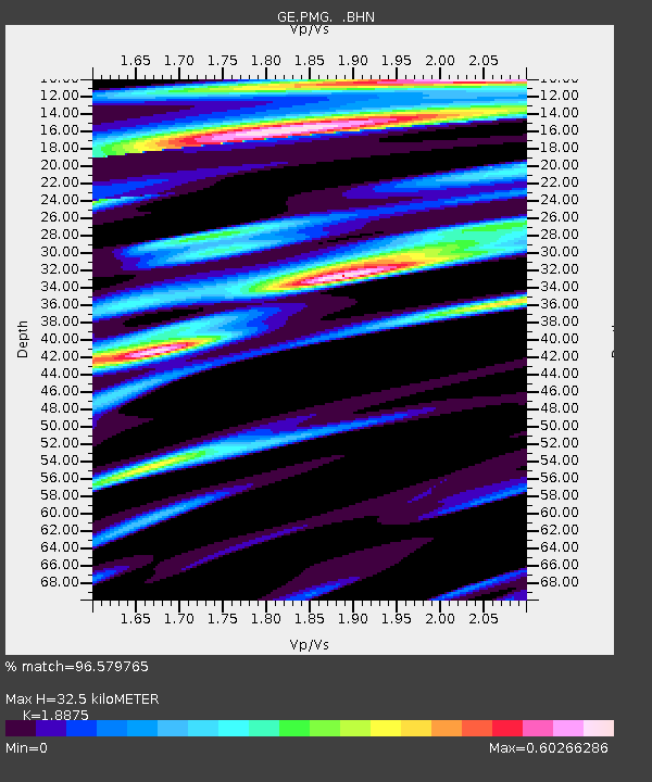
| Estimated Moho Depth: |
32.5 km |
| Estimated Crust Vp/Vs: |
1.89 |
| Assumed Crust Vp: |
6.122 km/s |
| Estimated Crust Vs: |
3.243 km/s |
| Estimated Crust Poisson's Ratio: |
0.30 |
|
| Radial Match: |
96.579765 % |
| Radial Bump: |
400 |
| Transverse Match: |
80.685646 % |
| Transverse Bump: |
400 |
| SOD ConfigId: |
6273 |
| Insert Time: |
2010-03-09 05:46:37.813 +0000 |
| GWidth: |
2.5 |
| Max Bumps: |
400 |
| Tol: |
0.001 |
|

Signal To Noise
| Channel | StoN | STA | LTA |
| GE:PMG: :BHN:19960207T21:45:39.191003Z | 2.9531713 | 6.341407E-7 | 2.1473211E-7 |
| GE:PMG: :BHE:19960207T21:45:39.191003Z | 1.3560294 | 3.0027593E-7 | 2.2143763E-7 |
| GE:PMG: :BHZ:19960207T21:45:39.191003Z | 7.712817 | 1.5010447E-6 | 1.9461692E-7 |
| Arrivals |
| Ps | 4.9 SECOND |
| PpPs | 15 SECOND |
| PsPs/PpSs | 20 SECOND |


