You are here: Home > Network List > UU - University of Utah Regional Network Stations List
> Station WPUT Wasatch Plateau, UT,USA > Earthquake Result Viewer
WPUT Wasatch Plateau, UT,USA - Earthquake Result Viewer

| Earthquake location: |
Tonga Islands |
| Earthquake latitude/longitude: |
-20.6/-173.9 |
| Earthquake time(UTC): |
2017/10/18 (291) 12:00:59 GMT |
| Earthquake Depth: |
10 km |
| Earthquake Magnitude: |
6.0 Mww |
| Earthquake Catalog/Contributor: |
NEIC PDE/us |
|
| Network: |
UU University of Utah Regional Network |
| Station: |
WPUT Wasatch Plateau, UT,USA |
| Lat/Lon: |
39.00 N/111.36 W |
| Elevation: |
2618 m |
|
| Distance: |
83.3 deg |
| Az: |
44.126 deg |
| Baz: |
236.831 deg |
| Ray Param: |
0.046320226 |
| Estimated Moho Depth: |
37.0 km |
| Estimated Crust Vp/Vs: |
2.06 |
| Assumed Crust Vp: |
6.207 km/s |
| Estimated Crust Vs: |
3.017 km/s |
| Estimated Crust Poisson's Ratio: |
0.35 |
|
| Radial Match: |
88.53944 % |
| Radial Bump: |
400 |
| Transverse Match: |
85.86819 % |
| Transverse Bump: |
397 |
| SOD ConfigId: |
2364251 |
| Insert Time: |
2017-11-01 12:14:19.148 +0000 |
| GWidth: |
2.5 |
| Max Bumps: |
400 |
| Tol: |
0.001 |
|
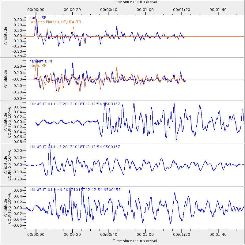
Signal To Noise
| Channel | StoN | STA | LTA |
| UU:WPUT:01:HHZ:20171018T12:12:54.950015Z | 6.524606 | 2.1740764E-8 | 3.3321188E-9 |
| UU:WPUT:01:HHN:20171018T12:12:54.950015Z | 1.2471961 | 5.876799E-9 | 4.712009E-9 |
| UU:WPUT:01:HHE:20171018T12:12:54.950015Z | 1.0158494 | 4.740824E-9 | 4.6668576E-9 |
| Arrivals |
| Ps | 6.4 SECOND |
| PpPs | 18 SECOND |
| PsPs/PpSs | 24 SECOND |


