You are here: Home > Network List > UU - University of Utah Regional Network Stations List
> Station ZNPU Zion National Park, UT, USA > Earthquake Result Viewer
ZNPU Zion National Park, UT, USA - Earthquake Result Viewer
| Earthquake location: |
Tonga Islands |
| Earthquake latitude/longitude: |
-20.6/-173.9 |
| Earthquake time(UTC): |
2017/10/18 (291) 12:00:59 GMT |
| Earthquake Depth: |
10 km |
| Earthquake Magnitude: |
6.0 Mww |
| Earthquake Catalog/Contributor: |
NEIC PDE/us |
|
| Network: |
UU University of Utah Regional Network |
| Station: |
ZNPU Zion National Park, UT, USA |
| Lat/Lon: |
37.36 N/113.13 W |
| Elevation: |
1953 m |
|
| Distance: |
81.2 deg |
| Az: |
44.723 deg |
| Baz: |
235.824 deg |
| Ray Param: |
0.04776379 |
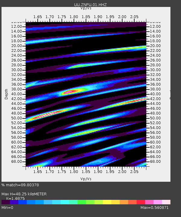
| Estimated Moho Depth: |
48.25 km |
| Estimated Crust Vp/Vs: |
1.69 |
| Assumed Crust Vp: |
6.194 km/s |
| Estimated Crust Vs: |
3.671 km/s |
| Estimated Crust Poisson's Ratio: |
0.23 |
|
| Radial Match: |
89.80378 % |
| Radial Bump: |
400 |
| Transverse Match: |
76.08974 % |
| Transverse Bump: |
400 |
| SOD ConfigId: |
2364251 |
| Insert Time: |
2017-11-01 12:14:19.899 +0000 |
| GWidth: |
2.5 |
| Max Bumps: |
400 |
| Tol: |
0.001 |
|

Signal To Noise
| Channel | StoN | STA | LTA |
| UU:ZNPU:01:HHZ:20171018T12:12:44.158022Z | 3.790235 | 2.1799325E-8 | 5.751444E-9 |
| UU:ZNPU:01:HHN:20171018T12:12:44.158022Z | 1.0991014 | 4.815128E-9 | 4.3809676E-9 |
| UU:ZNPU:01:HHE:20171018T12:12:44.158022Z | 1.6381595 | 5.1392237E-9 | 3.1371936E-9 |
| Arrivals |
| Ps | 5.5 SECOND |
| PpPs | 20 SECOND |
| PsPs/PpSs | 26 SECOND |


