You are here: Home > Network List > AV - Alaska Volcano Observatory Stations List
> Station SPCR Ckakachatna River, Mount Spurr, Alaska > Earthquake Result Viewer
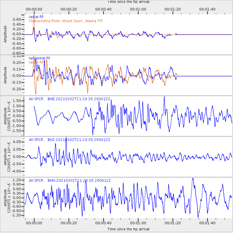
SPCR Ckakachatna River, Mount Spurr, Alaska - Earthquake Result Viewer
*The percent match for this event was below the threshold and hence no stack was calculated.
| Earthquake location: |
Kuril Islands |
| Earthquake latitude/longitude: |
44.0/147.9 |
| Earthquake time(UTC): |
2021/03/02 (061) 21:22:45 GMT |
| Earthquake Depth: |
28 km |
| Earthquake Magnitude: |
5.8 mww |
| Earthquake Catalog/Contributor: |
NEIC PDE/us |
|
| Network: |
AV Alaska Volcano Observatory |
| Station: |
SPCR Ckakachatna River, Mount Spurr, Alaska |
| Lat/Lon: |
61.20 N/152.21 W |
| Elevation: |
984 m |
|
| Distance: |
38.7 deg |
| Az: |
42.088 deg |
| Baz: |
271.68 deg |
| Ray Param: |
$rayparam |
*The percent match for this event was below the threshold and hence was not used in the summary stack. |
|
| Radial Match: |
70.5032 % |
| Radial Bump: |
400 |
| Transverse Match: |
61.265205 % |
| Transverse Bump: |
400 |
| SOD ConfigId: |
23341671 |
| Insert Time: |
2021-03-16 22:28:47.612 +0000 |
| GWidth: |
2.5 |
| Max Bumps: |
400 |
| Tol: |
0.001 |
|
Signal To Noise
| Channel | StoN | STA | LTA |
| AV:SPCR: :BHZ:20210302T21:29:36.260012Z | 3.6324615 | 1.2526697E-6 | 3.4485421E-7 |
| AV:SPCR: :BHN:20210302T21:29:36.260012Z | 0.7074913 | 3.1662202E-7 | 4.4752778E-7 |
| AV:SPCR: :BHE:20210302T21:29:36.260012Z | 2.0964448 | 7.692522E-7 | 3.6693177E-7 |
| Arrivals |
| Ps | |
| PpPs | |
| PsPs/PpSs | |


