You are here: Home > Network List > GE - GEOFON Stations List
> Station PMG IRIS/GEOFON/PACIFIC21 Station Port Moresby, PNG > Earthquake Result Viewer
PMG IRIS/GEOFON/PACIFIC21 Station Port Moresby, PNG - Earthquake Result Viewer
| Earthquake location: |
Panay, Philippines |
| Earthquake latitude/longitude: |
10.2/121.7 |
| Earthquake time(UTC): |
1997/05/12 (132) 13:45:26 GMT |
| Earthquake Depth: |
33 km |
| Earthquake Magnitude: |
5.5 MB, 5.8 MS, 6.1 UNKNOWN, 5.9 MW |
| Earthquake Catalog/Contributor: |
WHDF/NEIC |
|
| Network: |
GE GEOFON |
| Station: |
PMG IRIS/GEOFON/PACIFIC21 Station Port Moresby, PNG |
| Lat/Lon: |
9.41 S/147.15 E |
| Elevation: |
67 m |
|
| Distance: |
32.0 deg |
| Az: |
126.678 deg |
| Baz: |
306.855 deg |
| Ray Param: |
0.0787973 |
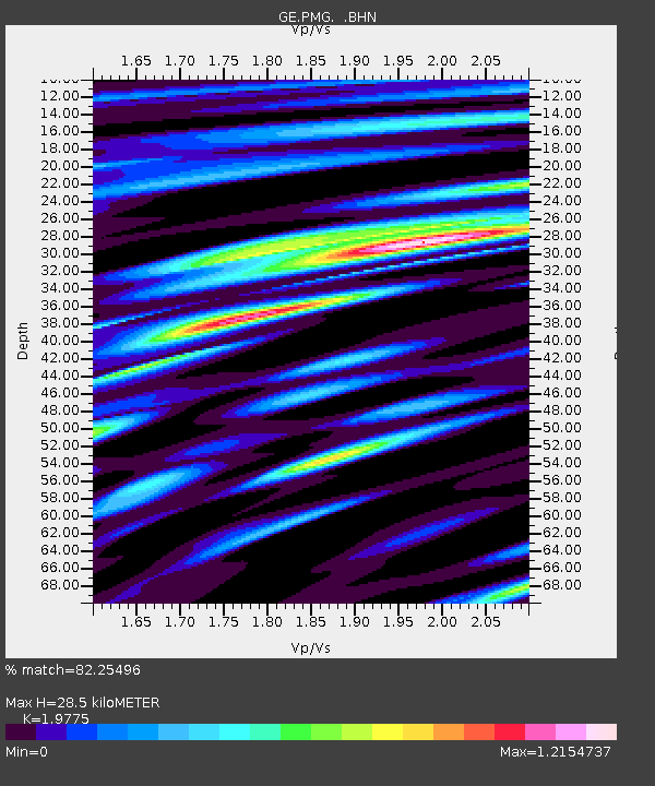
| Estimated Moho Depth: |
28.5 km |
| Estimated Crust Vp/Vs: |
1.98 |
| Assumed Crust Vp: |
6.122 km/s |
| Estimated Crust Vs: |
3.096 km/s |
| Estimated Crust Poisson's Ratio: |
0.33 |
|
| Radial Match: |
82.25496 % |
| Radial Bump: |
400 |
| Transverse Match: |
58.97157 % |
| Transverse Bump: |
400 |
| SOD ConfigId: |
6273 |
| Insert Time: |
2010-03-09 05:47:15.793 +0000 |
| GWidth: |
2.5 |
| Max Bumps: |
400 |
| Tol: |
0.001 |
|

Signal To Noise
| Channel | StoN | STA | LTA |
| GE:PMG: :BHN:19970512T13:51:19.013989Z | 4.4640927 | 7.0619694E-7 | 1.5819496E-7 |
| GE:PMG: :BHE:19970512T13:51:19.013989Z | 2.7358673 | 4.867222E-7 | 1.7790417E-7 |
| GE:PMG: :BHZ:19970512T13:51:19.013989Z | 10.057166 | 1.1447349E-6 | 1.13822814E-7 |
| Arrivals |
| Ps | 4.9 SECOND |
| PpPs | 13 SECOND |
| PsPs/PpSs | 18 SECOND |


