You are here: Home > Network List > GT - Global Telemetered Seismograph Network (USAF/USGS) Stations List
> Station BOSA Boshof, South Africa > Earthquake Result Viewer
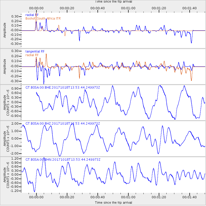
BOSA Boshof, South Africa - Earthquake Result Viewer
*The percent match for this event was below the threshold and hence no stack was calculated.
| Earthquake location: |
Minahassa Peninsula, Sulawesi |
| Earthquake latitude/longitude: |
-0.2/122.9 |
| Earthquake time(UTC): |
2017/10/18 (291) 13:40:55 GMT |
| Earthquake Depth: |
87 km |
| Earthquake Magnitude: |
5.3 Mww |
| Earthquake Catalog/Contributor: |
NEIC PDE/us |
|
| Network: |
GT Global Telemetered Seismograph Network (USAF/USGS) |
| Station: |
BOSA Boshof, South Africa |
| Lat/Lon: |
28.61 S/25.26 E |
| Elevation: |
1280 m |
|
| Distance: |
96.6 deg |
| Az: |
241.312 deg |
| Baz: |
93.836 deg |
| Ray Param: |
$rayparam |
*The percent match for this event was below the threshold and hence was not used in the summary stack. |
|
| Radial Match: |
85.84253 % |
| Radial Bump: |
400 |
| Transverse Match: |
70.65381 % |
| Transverse Bump: |
400 |
| SOD ConfigId: |
2364251 |
| Insert Time: |
2017-11-01 13:42:00.100 +0000 |
| GWidth: |
2.5 |
| Max Bumps: |
400 |
| Tol: |
0.001 |
|
Signal To Noise
| Channel | StoN | STA | LTA |
| GT:BOSA:00:BHZ:20171018T13:53:44.249973Z | 1.5690439 | 1.3574835E-6 | 8.6516604E-7 |
| GT:BOSA:00:BHN:20171018T13:53:44.249973Z | 1.2053735 | 5.9987383E-7 | 4.976663E-7 |
| GT:BOSA:00:BHE:20171018T13:53:44.249973Z | 1.1691924 | 4.6136807E-7 | 3.9460406E-7 |
| Arrivals |
| Ps | |
| PpPs | |
| PsPs/PpSs | |


