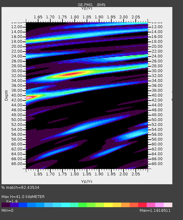
PMG IRIS/GEOFON/PACIFIC21 Station Port Moresby, PNG - Earthquake Result Viewer

Earthquake location: Fox Islands, Aleutian Islands
Earthquake latitude/longitude: 52.9/-169.1
Earthquake time(UTC): 1999/01/28 (028) 08:10:05 GMT
Earthquake Depth: 67 km
Earthquake Magnitude: 6.3 MB, 6.1 MS, 6.6 MW, 6.6 ME
Earthquake Catalog/Contributor: WHDF/NEIC
Network: GE GEOFON
Station: PMG IRIS/GEOFON/PACIFIC21 Station Port Moresby, PNG
Lat/Lon: 9.41 S/147.15 E
Elevation: 67 m
Distance: 72.4 deg
Az: 225.694 deg
Baz: 26.071 deg
Ray Param: 0.053561788
Estimated Moho Depth: 41.0 km
Estimated Crust Vp/Vs: 1.60
Assumed Crust Vp: 6.122 km/s
Estimated Crust Vs: 3.826 km/s
Estimated Crust Poisson's Ratio: 0.18
Radial Match: 92.43534 %
Radial Bump: 400
Transverse Match: 88.94338 %
Transverse Bump: 400
SOD ConfigId: 4480
Insert Time: 2010-03-09 05:47:45.779 +0000
GWidth: 2.5
Max Bumps: 400
Tol: 0.001

Signal To Noise

ChannelStoNSTALTA
GE:PMG: :BHN:19990128T08:20:53.276995Z66.321874.527208E-66.8261166E-8
GE:PMG: :BHE:19990128T08:20:53.276995Z24.8848551.8468838E-67.421718E-8
GE:PMG: :BHZ:19990128T08:20:53.276995Z10.76845559.0540357E-78.407924E-8
Arrivals
Ps4.2 SECOND
PpPs17 SECOND
PsPs/PpSs21 SECOND