You are here: Home > Network List > GE - GEOFON Stations List
> Station PMG IRIS/GEOFON/PACIFIC21 Station Port Moresby, PNG > Earthquake Result Viewer
PMG IRIS/GEOFON/PACIFIC21 Station Port Moresby, PNG - Earthquake Result Viewer
| Earthquake location: |
Kuril Islands |
| Earthquake latitude/longitude: |
44.8/147.2 |
| Earthquake time(UTC): |
2000/12/22 (357) 10:13:01 GMT |
| Earthquake Depth: |
140 km |
| Earthquake Magnitude: |
6.0 MB, 6.2 MW, 6.2 MW |
| Earthquake Catalog/Contributor: |
WHDF/NEIC |
|
| Network: |
GE GEOFON |
| Station: |
PMG IRIS/GEOFON/PACIFIC21 Station Port Moresby, PNG |
| Lat/Lon: |
9.41 S/147.15 E |
| Elevation: |
67 m |
|
| Distance: |
53.9 deg |
| Az: |
180.051 deg |
| Baz: |
0.037 deg |
| Ray Param: |
0.06531457 |
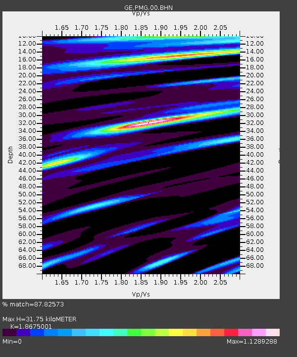
| Estimated Moho Depth: |
31.75 km |
| Estimated Crust Vp/Vs: |
1.87 |
| Assumed Crust Vp: |
6.122 km/s |
| Estimated Crust Vs: |
3.278 km/s |
| Estimated Crust Poisson's Ratio: |
0.30 |
|
| Radial Match: |
87.82573 % |
| Radial Bump: |
400 |
| Transverse Match: |
81.27603 % |
| Transverse Bump: |
400 |
| SOD ConfigId: |
20082 |
| Insert Time: |
2010-03-09 05:47:49.188 +0000 |
| GWidth: |
2.5 |
| Max Bumps: |
400 |
| Tol: |
0.001 |
|

Signal To Noise
| Channel | StoN | STA | LTA |
| GE:PMG:00:BHN:20001222T10:21:39.675002Z | 13.372338 | 1.7716692E-6 | 1.324876E-7 |
| GE:PMG:00:BHE:20001222T10:21:39.675002Z | 3.0972319 | 4.4447145E-7 | 1.4350603E-7 |
| GE:PMG:00:BHZ:20001222T10:21:39.675002Z | 24.849558 | 3.8172634E-6 | 1.5361493E-7 |
| Arrivals |
| Ps | 4.7 SECOND |
| PpPs | 14 SECOND |
| PsPs/PpSs | 19 SECOND |


