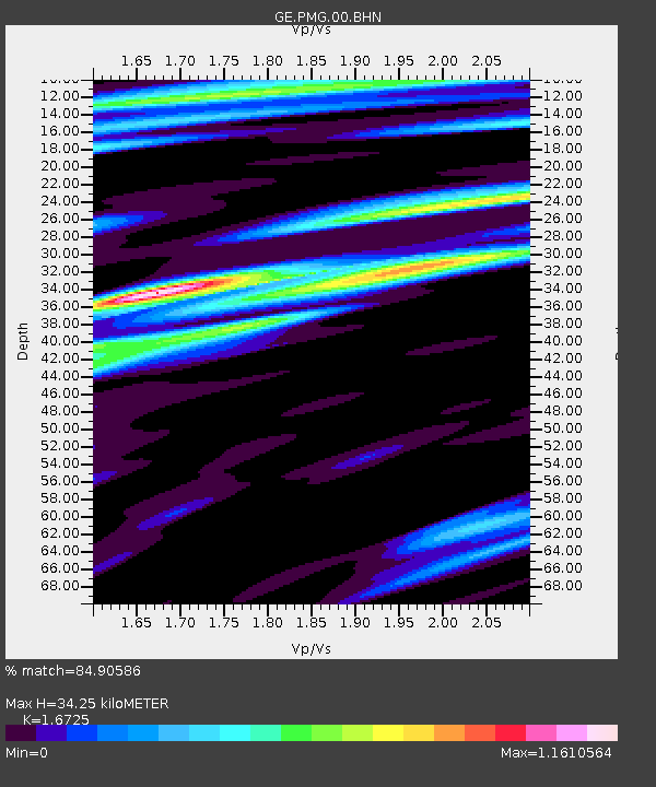
PMG IRIS/GEOFON/PACIFIC21 Station Port Moresby, PNG - Earthquake Result Viewer

Earthquake location: Southern Sumatra, Indonesia
Earthquake latitude/longitude: -5.4/102.7
Earthquake time(UTC): 2000/07/08 (190) 04:52:55 GMT
Earthquake Depth: 33 km
Earthquake Magnitude: 5.7 MB, 5.7 MS, 5.9 MW, 5.8 MW
Earthquake Catalog/Contributor: WHDF/NEIC
Network: GE GEOFON
Station: PMG IRIS/GEOFON/PACIFIC21 Station Port Moresby, PNG
Lat/Lon: 9.41 S/147.15 E
Elevation: 67 m
Distance: 44.2 deg
Az: 97.89 deg
Baz: 271.893 deg
Ray Param: 0.07197565
Estimated Moho Depth: 34.25 km
Estimated Crust Vp/Vs: 1.67
Assumed Crust Vp: 6.122 km/s
Estimated Crust Vs: 3.66 km/s
Estimated Crust Poisson's Ratio: 0.22
Radial Match: 84.90586 %
Radial Bump: 400
Transverse Match: 76.315445 %
Transverse Bump: 400
SOD ConfigId: 20082
Insert Time: 2010-03-09 05:48:19.927 +0000
GWidth: 2.5
Max Bumps: 400
Tol: 0.001

Signal To Noise

ChannelStoNSTALTA
GE:PMG:00:BHN:20000708T05:00:31.088009Z1.91092132.6730527E-71.3988293E-7
GE:PMG:00:BHE:20000708T05:00:31.088009Z3.15918563.9618456E-71.2540718E-7
GE:PMG:00:BHZ:20000708T05:00:31.088009Z5.12512838.5798285E-71.674071E-7
Arrivals
Ps4.0 SECOND
PpPs14 SECOND
PsPs/PpSs18 SECOND