You are here: Home > Network List > GE - GEOFON Stations List
> Station PMG IRIS/GEOFON/PACIFIC21 Station Port Moresby, PNG > Earthquake Result Viewer
PMG IRIS/GEOFON/PACIFIC21 Station Port Moresby, PNG - Earthquake Result Viewer
| Earthquake location: |
South Of Fiji Islands |
| Earthquake latitude/longitude: |
-25.5/178.0 |
| Earthquake time(UTC): |
2000/06/14 (166) 02:15:25 GMT |
| Earthquake Depth: |
605 km |
| Earthquake Magnitude: |
5.9 MB, 6.4 MW, 6.4 MW |
| Earthquake Catalog/Contributor: |
WHDF/NEIC |
|
| Network: |
GE GEOFON |
| Station: |
PMG IRIS/GEOFON/PACIFIC21 Station Port Moresby, PNG |
| Lat/Lon: |
9.41 S/147.15 E |
| Elevation: |
67 m |
|
| Distance: |
33.4 deg |
| Az: |
293.091 deg |
| Baz: |
122.608 deg |
| Ray Param: |
0.075192176 |
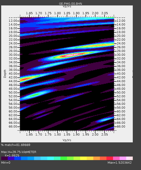
| Estimated Moho Depth: |
29.75 km |
| Estimated Crust Vp/Vs: |
1.88 |
| Assumed Crust Vp: |
6.122 km/s |
| Estimated Crust Vs: |
3.252 km/s |
| Estimated Crust Poisson's Ratio: |
0.30 |
|
| Radial Match: |
81.69669 % |
| Radial Bump: |
400 |
| Transverse Match: |
73.587585 % |
| Transverse Bump: |
400 |
| SOD ConfigId: |
20082 |
| Insert Time: |
2010-03-09 05:48:23.056 +0000 |
| GWidth: |
2.5 |
| Max Bumps: |
400 |
| Tol: |
0.001 |
|

Signal To Noise
| Channel | StoN | STA | LTA |
| GE:PMG:00:BHN:20000614T02:20:45.823002Z | 1.6144626 | 4.649482E-7 | 2.8798945E-7 |
| GE:PMG:00:BHE:20000614T02:20:45.823002Z | 2.4615688 | 1.1937879E-6 | 4.849703E-7 |
| GE:PMG:00:BHZ:20000614T02:20:45.823002Z | 9.611531 | 3.089448E-6 | 3.2143143E-7 |
| Arrivals |
| Ps | 4.6 SECOND |
| PpPs | 13 SECOND |
| PsPs/PpSs | 18 SECOND |


