You are here: Home > Network List > G - GEOSCOPE Stations List
> Station CLF Chambon la Foret observatory, France > Earthquake Result Viewer
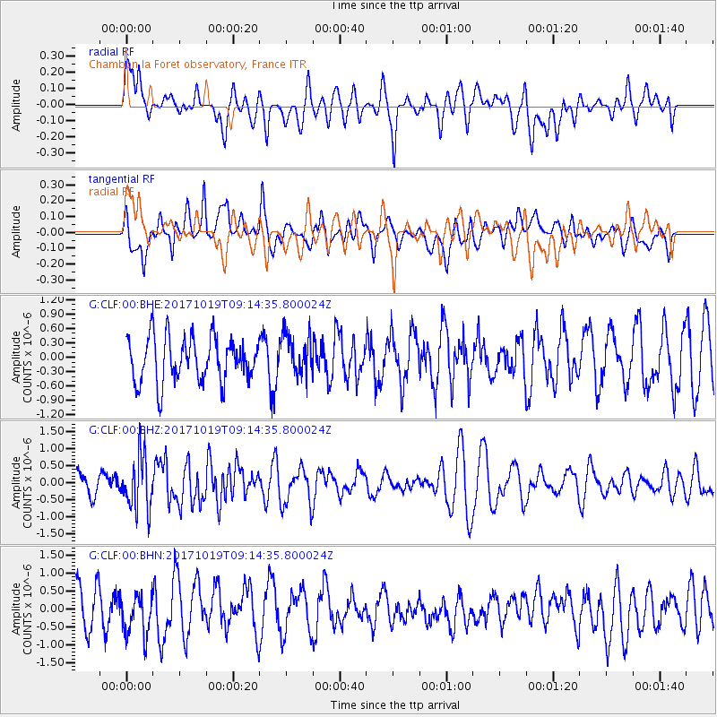
CLF Chambon la Foret observatory, France - Earthquake Result Viewer
*The percent match for this event was below the threshold and hence no stack was calculated.
| Earthquake location: |
Southeast Of Ryukyu Islands |
| Earthquake latitude/longitude: |
28.3/131.2 |
| Earthquake time(UTC): |
2017/10/19 (292) 09:02:01 GMT |
| Earthquake Depth: |
10 km |
| Earthquake Magnitude: |
5.8 Mww |
| Earthquake Catalog/Contributor: |
NEIC PDE/us |
|
| Network: |
G GEOSCOPE |
| Station: |
CLF Chambon la Foret observatory, France |
| Lat/Lon: |
48.03 N/2.26 E |
| Elevation: |
145 m |
|
| Distance: |
91.3 deg |
| Az: |
328.517 deg |
| Baz: |
43.306 deg |
| Ray Param: |
$rayparam |
*The percent match for this event was below the threshold and hence was not used in the summary stack. |
|
| Radial Match: |
46.396706 % |
| Radial Bump: |
400 |
| Transverse Match: |
43.5819 % |
| Transverse Bump: |
400 |
| SOD ConfigId: |
2364251 |
| Insert Time: |
2017-11-02 09:03:20.690 +0000 |
| GWidth: |
2.5 |
| Max Bumps: |
400 |
| Tol: |
0.001 |
|
Signal To Noise
| Channel | StoN | STA | LTA |
| G:CLF:00:BHZ:20171019T09:14:35.800024Z | 1.7263052 | 7.8654085E-7 | 4.5562095E-7 |
| G:CLF:00:BHN:20171019T09:14:35.800024Z | 1.0448214 | 5.921654E-7 | 5.667623E-7 |
| G:CLF:00:BHE:20171019T09:14:35.800024Z | 0.94933945 | 4.3980575E-7 | 4.632755E-7 |
| Arrivals |
| Ps | |
| PpPs | |
| PsPs/PpSs | |


