You are here: Home > Network List > TA - USArray Transportable Network (new EarthScope stations) Stations List
> Station H31M Peel River, Yukon, CAN > Earthquake Result Viewer
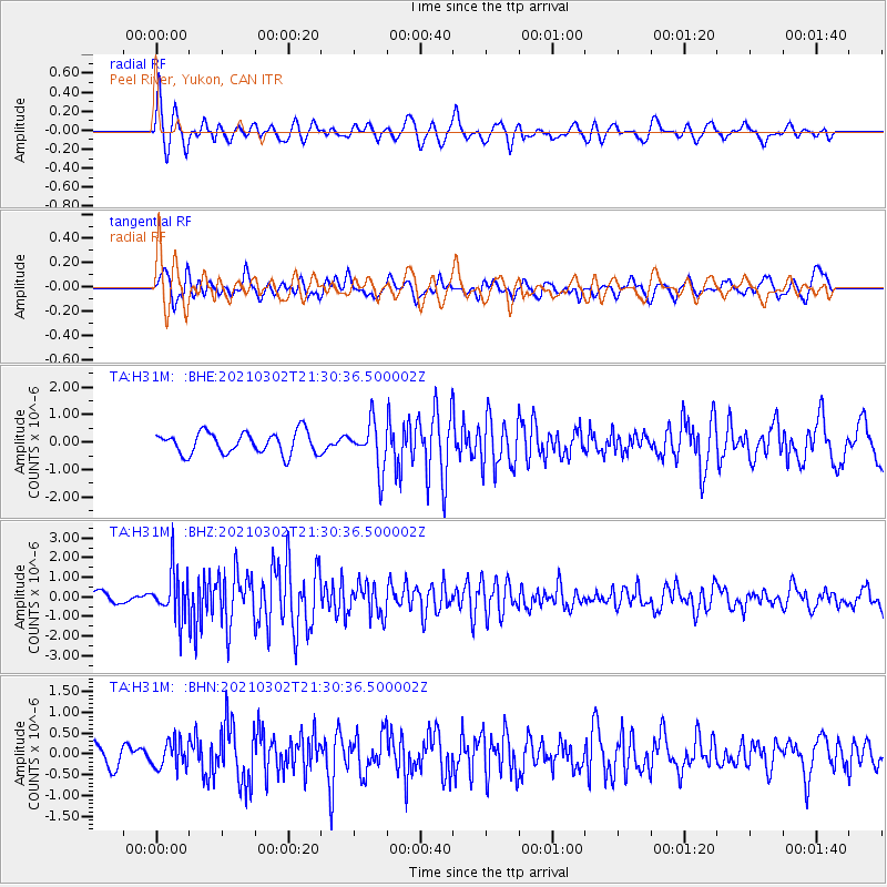
H31M Peel River, Yukon, CAN - Earthquake Result Viewer
*The percent match for this event was below the threshold and hence no stack was calculated.
| Earthquake location: |
Kuril Islands |
| Earthquake latitude/longitude: |
44.0/147.9 |
| Earthquake time(UTC): |
2021/03/02 (061) 21:22:45 GMT |
| Earthquake Depth: |
28 km |
| Earthquake Magnitude: |
5.8 mww |
| Earthquake Catalog/Contributor: |
NEIC PDE/us |
|
| Network: |
TA USArray Transportable Network (new EarthScope stations) |
| Station: |
H31M Peel River, Yukon, CAN |
| Lat/Lon: |
65.81 N/134.34 W |
| Elevation: |
642 m |
|
| Distance: |
46.1 deg |
| Az: |
33.979 deg |
| Baz: |
281.683 deg |
| Ray Param: |
$rayparam |
*The percent match for this event was below the threshold and hence was not used in the summary stack. |
|
| Radial Match: |
60.607487 % |
| Radial Bump: |
400 |
| Transverse Match: |
62.89158 % |
| Transverse Bump: |
400 |
| SOD ConfigId: |
23341671 |
| Insert Time: |
2021-03-16 22:45:48.375 +0000 |
| GWidth: |
2.5 |
| Max Bumps: |
400 |
| Tol: |
0.001 |
|
Signal To Noise
| Channel | StoN | STA | LTA |
| TA:H31M: :BHZ:20210302T21:30:36.500002Z | 3.7978792 | 1.2187589E-6 | 3.2090512E-7 |
| TA:H31M: :BHN:20210302T21:30:36.500002Z | 0.83606035 | 3.2102392E-7 | 3.839722E-7 |
| TA:H31M: :BHE:20210302T21:30:36.500002Z | 2.1637194 | 8.563215E-7 | 3.9576366E-7 |
| Arrivals |
| Ps | |
| PpPs | |
| PsPs/PpSs | |


