You are here: Home > Network List > TA - USArray Transportable Network (new EarthScope stations) Stations List
> Station I17K Unalakleet, AK, USA > Earthquake Result Viewer
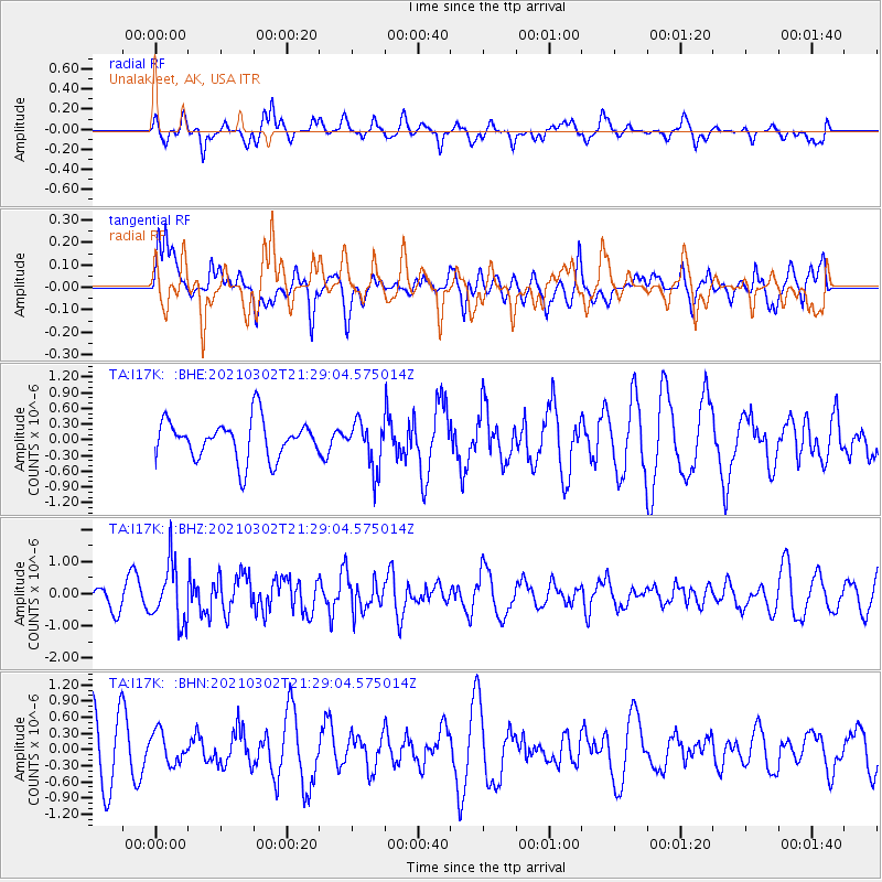
I17K Unalakleet, AK, USA - Earthquake Result Viewer
*The percent match for this event was below the threshold and hence no stack was calculated.
| Earthquake location: |
Kuril Islands |
| Earthquake latitude/longitude: |
44.0/147.9 |
| Earthquake time(UTC): |
2021/03/02 (061) 21:22:45 GMT |
| Earthquake Depth: |
28 km |
| Earthquake Magnitude: |
5.8 mww |
| Earthquake Catalog/Contributor: |
NEIC PDE/us |
|
| Network: |
TA USArray Transportable Network (new EarthScope stations) |
| Station: |
I17K Unalakleet, AK, USA |
| Lat/Lon: |
63.89 N/160.70 W |
| Elevation: |
105 m |
|
| Distance: |
35.0 deg |
| Az: |
37.148 deg |
| Baz: |
260.199 deg |
| Ray Param: |
$rayparam |
*The percent match for this event was below the threshold and hence was not used in the summary stack. |
|
| Radial Match: |
51.53255 % |
| Radial Bump: |
364 |
| Transverse Match: |
48.266304 % |
| Transverse Bump: |
400 |
| SOD ConfigId: |
23341671 |
| Insert Time: |
2021-03-16 22:45:50.012 +0000 |
| GWidth: |
2.5 |
| Max Bumps: |
400 |
| Tol: |
0.001 |
|
Signal To Noise
| Channel | StoN | STA | LTA |
| TA:I17K: :BHZ:20210302T21:29:04.575014Z | 3.3451724 | 9.2934664E-7 | 2.7781726E-7 |
| TA:I17K: :BHN:20210302T21:29:04.575014Z | 0.47896618 | 2.901069E-7 | 6.056939E-7 |
| TA:I17K: :BHE:20210302T21:29:04.575014Z | 1.1841011 | 4.4583496E-7 | 3.7651765E-7 |
| Arrivals |
| Ps | |
| PpPs | |
| PsPs/PpSs | |


