You are here: Home > Network List > GE - GEOFON Stations List
> Station PMG IRIS/GEOFON/PACIFIC21 Station Port Moresby, PNG > Earthquake Result Viewer
PMG IRIS/GEOFON/PACIFIC21 Station Port Moresby, PNG - Earthquake Result Viewer
| Earthquake location: |
Samar, Philippines |
| Earthquake latitude/longitude: |
12.2/125.7 |
| Earthquake time(UTC): |
1995/05/24 (144) 20:21:25 GMT |
| Earthquake Depth: |
33 km |
| Earthquake Magnitude: |
5.7 MS, 5.4 MB |
| Earthquake Catalog/Contributor: |
WHDF/NEIC |
|
| Network: |
GE GEOFON |
| Station: |
PMG IRIS/GEOFON/PACIFIC21 Station Port Moresby, PNG |
| Lat/Lon: |
9.41 S/147.15 E |
| Elevation: |
67 m |
|
| Distance: |
30.3 deg |
| Az: |
134.269 deg |
| Baz: |
314.805 deg |
| Ray Param: |
0.07934931 |
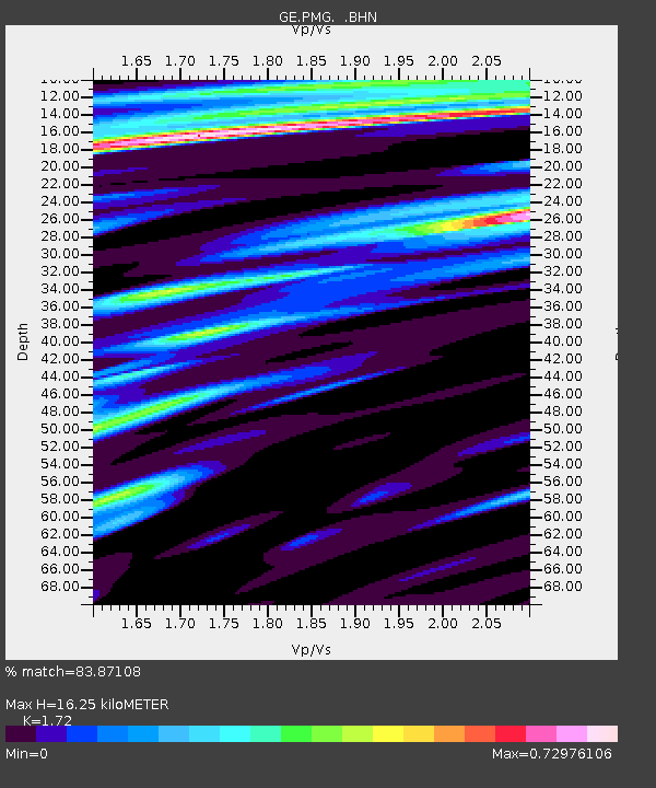
| Estimated Moho Depth: |
16.25 km |
| Estimated Crust Vp/Vs: |
1.72 |
| Assumed Crust Vp: |
6.122 km/s |
| Estimated Crust Vs: |
3.559 km/s |
| Estimated Crust Poisson's Ratio: |
0.24 |
|
| Radial Match: |
83.87108 % |
| Radial Bump: |
400 |
| Transverse Match: |
62.992466 % |
| Transverse Bump: |
400 |
| SOD ConfigId: |
4480 |
| Insert Time: |
2010-03-09 05:48:50.816 +0000 |
| GWidth: |
2.5 |
| Max Bumps: |
400 |
| Tol: |
0.001 |
|

Signal To Noise
| Channel | StoN | STA | LTA |
| GE:PMG: :BHN:19950524T20:27:02.652002Z | 3.4880693 | 4.8617443E-7 | 1.393821E-7 |
| GE:PMG: :BHE:19950524T20:27:02.652002Z | 1.108735 | 1.5756405E-7 | 1.4211156E-7 |
| GE:PMG: :BHZ:19950524T20:27:02.652002Z | 2.4568055 | 2.4999068E-7 | 1.0175436E-7 |
| Arrivals |
| Ps | 2.1 SECOND |
| PpPs | 6.7 SECOND |
| PsPs/PpSs | 8.8 SECOND |


