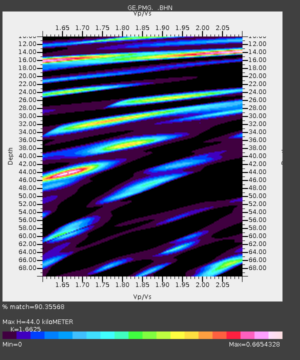
PMG IRIS/GEOFON/PACIFIC21 Station Port Moresby, PNG - Earthquake Result Viewer

Earthquake location: Western Xizang-India Border Reg.
Earthquake latitude/longitude: 30.5/79.4
Earthquake time(UTC): 1999/03/28 (087) 19:05:11 GMT
Earthquake Depth: 15 km
Earthquake Magnitude: 6.4 MB, 6.6 MS, 6.6 MW, 6.5 ME
Earthquake Catalog/Contributor: WHDF/NEIC
Network: GE GEOFON
Station: PMG IRIS/GEOFON/PACIFIC21 Station Port Moresby, PNG
Lat/Lon: 9.41 S/147.15 E
Elevation: 67 m
Distance: 76.1 deg
Az: 109.807 deg
Baz: 304.626 deg
Ray Param: 0.051217988
Estimated Moho Depth: 44.0 km
Estimated Crust Vp/Vs: 1.66
Assumed Crust Vp: 6.122 km/s
Estimated Crust Vs: 3.682 km/s
Estimated Crust Poisson's Ratio: 0.22
Radial Match: 90.35568 %
Radial Bump: 400
Transverse Match: 88.46841 %
Transverse Bump: 400
SOD ConfigId: 4480
Insert Time: 2010-03-09 05:48:53.950 +0000
GWidth: 2.5
Max Bumps: 400
Tol: 0.001

Signal To Noise

ChannelStoNSTALTA
GE:PMG: :BHN:19990328T19:16:26.615022Z1.92599033.0134805E-71.5646394E-7
GE:PMG: :BHE:19990328T19:16:26.615022Z0.685634439.728403E-81.4188907E-7
GE:PMG: :BHZ:19990328T19:16:26.615022Z0.734808861.2053187E-71.6403159E-7
Arrivals
Ps4.9 SECOND
PpPs19 SECOND
PsPs/PpSs23 SECOND