You are here: Home > Network List > GE - GEOFON Stations List
> Station PMG IRIS/GEOFON/PACIFIC21 Station Port Moresby, PNG > Earthquake Result Viewer
PMG IRIS/GEOFON/PACIFIC21 Station Port Moresby, PNG - Earthquake Result Viewer
| Earthquake location: |
Fiji Islands Region |
| Earthquake latitude/longitude: |
-16.5/-177.5 |
| Earthquake time(UTC): |
2001/12/03 (337) 11:32:29 GMT |
| Earthquake Depth: |
10 km |
| Earthquake Magnitude: |
5.7 MB, 6.1 MS, 6.4 MW, 6.3 MW |
| Earthquake Catalog/Contributor: |
WHDF/NEIC |
|
| Network: |
GE GEOFON |
| Station: |
PMG IRIS/GEOFON/PACIFIC21 Station Port Moresby, PNG |
| Lat/Lon: |
9.41 S/147.15 E |
| Elevation: |
67 m |
|
| Distance: |
35.1 deg |
| Az: |
277.139 deg |
| Baz: |
105.263 deg |
| Ray Param: |
0.07740953 |
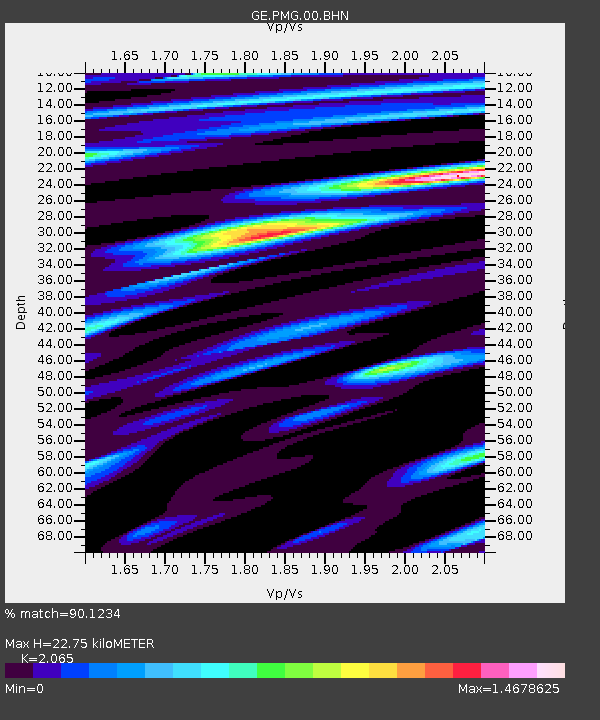
| Estimated Moho Depth: |
22.75 km |
| Estimated Crust Vp/Vs: |
2.07 |
| Assumed Crust Vp: |
6.122 km/s |
| Estimated Crust Vs: |
2.965 km/s |
| Estimated Crust Poisson's Ratio: |
0.35 |
|
| Radial Match: |
90.1234 % |
| Radial Bump: |
400 |
| Transverse Match: |
83.63785 % |
| Transverse Bump: |
400 |
| SOD ConfigId: |
20082 |
| Insert Time: |
2010-03-09 05:49:08.287 +0000 |
| GWidth: |
2.5 |
| Max Bumps: |
400 |
| Tol: |
0.001 |
|

Signal To Noise
| Channel | StoN | STA | LTA |
| GE:PMG:00:BHN:20011203T11:38:52.18501Z | 0.9021698 | 5.484327E-8 | 6.0790406E-8 |
| GE:PMG:00:BHE:20011203T11:38:52.18501Z | 1.0912956 | 9.151391E-8 | 8.385804E-8 |
| GE:PMG:00:BHZ:20011203T11:38:52.18501Z | 3.0591364 | 2.1246966E-7 | 6.945413E-8 |
| Arrivals |
| Ps | 4.2 SECOND |
| PpPs | 11 SECOND |
| PsPs/PpSs | 15 SECOND |


