You are here: Home > Network List > AK - Alaska Regional Network Stations List
> Station A21K Barrow, AK, USA > Earthquake Result Viewer
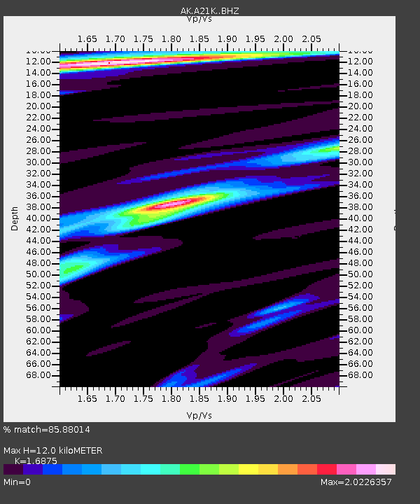
A21K Barrow, AK, USA - Earthquake Result Viewer
| Earthquake location: |
Greece |
| Earthquake latitude/longitude: |
39.8/22.2 |
| Earthquake time(UTC): |
2021/03/03 (062) 10:16:10 GMT |
| Earthquake Depth: |
10 km |
| Earthquake Magnitude: |
6.3 Mww |
| Earthquake Catalog/Contributor: |
NEIC PDE/us |
|
| Network: |
AK Alaska Regional Network |
| Station: |
A21K Barrow, AK, USA |
| Lat/Lon: |
71.32 N/156.62 W |
| Elevation: |
5.0 m |
|
| Distance: |
69.2 deg |
| Az: |
359.584 deg |
| Baz: |
0.995 deg |
| Ray Param: |
0.055795748 |
| Estimated Moho Depth: |
12.0 km |
| Estimated Crust Vp/Vs: |
1.69 |
| Assumed Crust Vp: |
6.048 km/s |
| Estimated Crust Vs: |
3.584 km/s |
| Estimated Crust Poisson's Ratio: |
0.23 |
|
| Radial Match: |
85.88014 % |
| Radial Bump: |
320 |
| Transverse Match: |
82.53631 % |
| Transverse Bump: |
400 |
| SOD ConfigId: |
23341671 |
| Insert Time: |
2021-03-17 11:17:53.785 +0000 |
| GWidth: |
2.5 |
| Max Bumps: |
400 |
| Tol: |
0.001 |
|

Signal To Noise
| Channel | StoN | STA | LTA |
| AK:A21K: :BHZ:20210303T10:26:45.819986Z | 9.277311 | 8.1430545E-7 | 8.7773856E-8 |
| AK:A21K: :BHN:20210303T10:26:45.819986Z | 1.3163548 | 2.7425725E-7 | 2.08346E-7 |
| AK:A21K: :BHE:20210303T10:26:45.819986Z | 1.580397 | 2.485967E-7 | 1.5730016E-7 |
| Arrivals |
| Ps | 1.4 SECOND |
| PpPs | 5.1 SECOND |
| PsPs/PpSs | 6.6 SECOND |


